You are here: Home > Network List > TX - Texas Seismological Network Stations List
> Station SNAG San Augustine > Earthquake Result Viewer
SNAG San Augustine - Earthquake Result Viewer
| Earthquake location: |
Peru-Ecuador Border Region |
| Earthquake latitude/longitude: |
-4.9/-80.6 |
| Earthquake time(UTC): |
2021/07/30 (211) 17:10:19 GMT |
| Earthquake Depth: |
33 km |
| Earthquake Magnitude: |
6.2 Mww |
| Earthquake Catalog/Contributor: |
NEIC PDE/us |
|
| Network: |
TX Texas Seismological Network |
| Station: |
SNAG San Augustine |
| Lat/Lon: |
31.52 N/94.18 W |
| Elevation: |
84 m |
|
| Distance: |
38.5 deg |
| Az: |
341.21 deg |
| Baz: |
157.928 deg |
| Ray Param: |
0.075495966 |
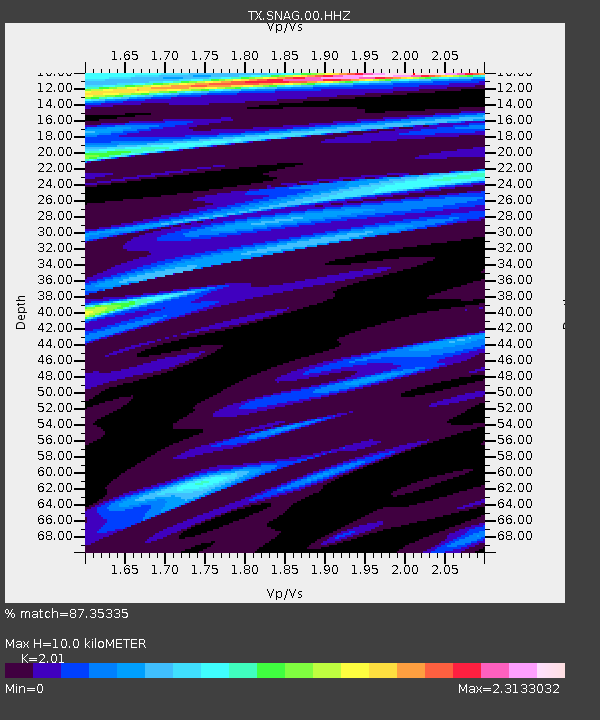
| Estimated Moho Depth: |
10.0 km |
| Estimated Crust Vp/Vs: |
2.01 |
| Assumed Crust Vp: |
5.738 km/s |
| Estimated Crust Vs: |
2.855 km/s |
| Estimated Crust Poisson's Ratio: |
0.34 |
|
| Radial Match: |
87.35335 % |
| Radial Bump: |
362 |
| Transverse Match: |
64.144615 % |
| Transverse Bump: |
400 |
| SOD ConfigId: |
25131211 |
| Insert Time: |
2021-08-13 17:42:55.701 +0000 |
| GWidth: |
2.5 |
| Max Bumps: |
400 |
| Tol: |
0.001 |
|
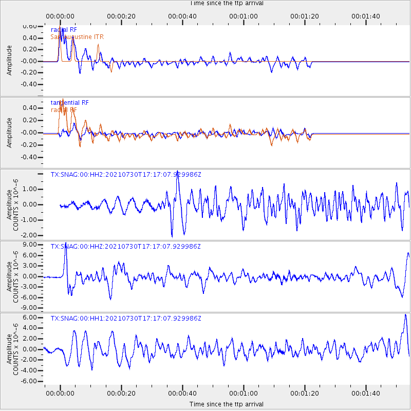
Signal To Noise
| Channel | StoN | STA | LTA |
| TX:SNAG:00:HHZ:20210730T17:17:07.929986Z | 46.41104 | 3.866309E-6 | 8.33058E-8 |
| TX:SNAG:00:HH1:20210730T17:17:07.929986Z | 10.775537 | 1.8527834E-6 | 1.719435E-7 |
| TX:SNAG:00:HH2:20210730T17:17:07.929986Z | 0.91238695 | 2.3147773E-7 | 2.5370565E-7 |
| Arrivals |
| Ps | 1.8 SECOND |
| PpPs | 5.0 SECOND |
| PsPs/PpSs | 6.8 SECOND |


