You are here: Home > Network List > NM - Cooperative New Madrid Seismic Network Stations List
> Station BLO Bloomington, IN > Earthquake Result Viewer
BLO Bloomington, IN - Earthquake Result Viewer
| Earthquake location: |
Near Coast Of Peru |
| Earthquake latitude/longitude: |
-16.7/-72.7 |
| Earthquake time(UTC): |
1999/04/03 (093) 06:17:18 GMT |
| Earthquake Depth: |
87 km |
| Earthquake Magnitude: |
6.1 MB, 6.2 MS, 6.8 MW, 6.8 MW |
| Earthquake Catalog/Contributor: |
WHDF/NEIC |
|
| Network: |
NM Cooperative New Madrid Seismic Network |
| Station: |
BLO Bloomington, IN |
| Lat/Lon: |
39.17 N/86.52 W |
| Elevation: |
246 m |
|
| Distance: |
57.0 deg |
| Az: |
347.176 deg |
| Baz: |
164.116 deg |
| Ray Param: |
0.06350508 |
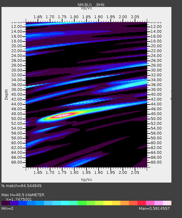
| Estimated Moho Depth: |
48.5 km |
| Estimated Crust Vp/Vs: |
1.75 |
| Assumed Crust Vp: |
6.444 km/s |
| Estimated Crust Vs: |
3.687 km/s |
| Estimated Crust Poisson's Ratio: |
0.26 |
|
| Radial Match: |
94.544945 % |
| Radial Bump: |
330 |
| Transverse Match: |
85.87708 % |
| Transverse Bump: |
400 |
| SOD ConfigId: |
4480 |
| Insert Time: |
2010-03-09 11:10:53.469 +0000 |
| GWidth: |
2.5 |
| Max Bumps: |
400 |
| Tol: |
0.001 |
|

Signal To Noise
| Channel | StoN | STA | LTA |
| NM:BLO: :BHN:19990403T06:26:24.591018Z | 8.832626 | 2.9961382E-6 | 3.3921262E-7 |
| NM:BLO: :BHE:19990403T06:26:24.591018Z | 4.447523 | 1.1666046E-6 | 2.6230433E-7 |
| NM:BLO: :BHZ:19990403T06:26:24.591018Z | 1.5412828 | 4.868404E-7 | 3.1586703E-7 |
| Arrivals |
| Ps | 5.9 SECOND |
| PpPs | 20 SECOND |
| PsPs/PpSs | 26 SECOND |


