You are here: Home > Network List > UO - University of Oregon Regional Network Stations List
> Station LAIR Myrtle Point, OR, USA > Earthquake Result Viewer
LAIR Myrtle Point, OR, USA - Earthquake Result Viewer
| Earthquake location: |
Peru-Ecuador Border Region |
| Earthquake latitude/longitude: |
-4.9/-80.6 |
| Earthquake time(UTC): |
2021/07/30 (211) 17:10:19 GMT |
| Earthquake Depth: |
33 km |
| Earthquake Magnitude: |
6.2 Mww |
| Earthquake Catalog/Contributor: |
NEIC PDE/us |
|
| Network: |
UO University of Oregon Regional Network |
| Station: |
LAIR Myrtle Point, OR, USA |
| Lat/Lon: |
43.16 N/123.93 W |
| Elevation: |
128 m |
|
| Distance: |
61.8 deg |
| Az: |
325.281 deg |
| Baz: |
129.146 deg |
| Ray Param: |
0.06057338 |
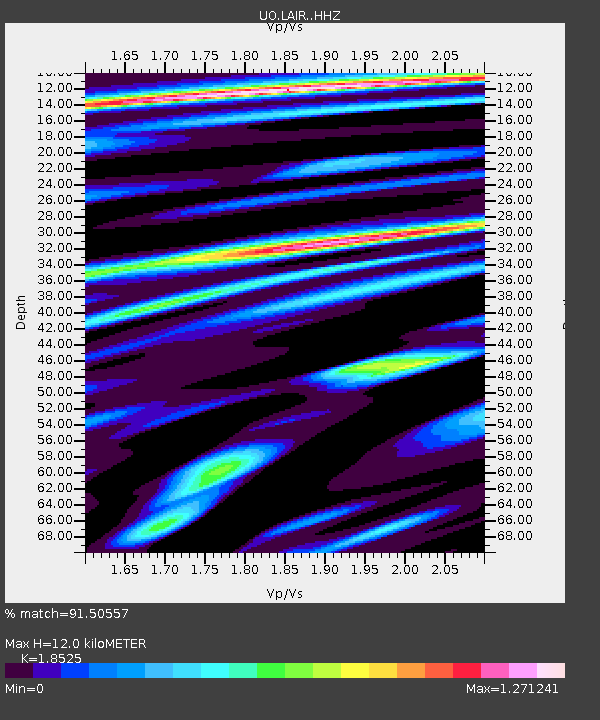
| Estimated Moho Depth: |
12.0 km |
| Estimated Crust Vp/Vs: |
1.85 |
| Assumed Crust Vp: |
6.522 km/s |
| Estimated Crust Vs: |
3.52 km/s |
| Estimated Crust Poisson's Ratio: |
0.29 |
|
| Radial Match: |
91.50557 % |
| Radial Bump: |
400 |
| Transverse Match: |
84.936356 % |
| Transverse Bump: |
400 |
| SOD ConfigId: |
25131211 |
| Insert Time: |
2021-08-13 17:43:32.611 +0000 |
| GWidth: |
2.5 |
| Max Bumps: |
400 |
| Tol: |
0.001 |
|

Signal To Noise
| Channel | StoN | STA | LTA |
| UO:LAIR: :HHZ:20210730T17:20:04.317986Z | 38.68465 | 5.7157868E-6 | 1.4775334E-7 |
| UO:LAIR: :HHN:20210730T17:20:04.317986Z | 5.06635 | 1.0903013E-6 | 2.1520451E-7 |
| UO:LAIR: :HHE:20210730T17:20:04.317986Z | 4.4944663 | 1.1748209E-6 | 2.6139273E-7 |
| Arrivals |
| Ps | 1.6 SECOND |
| PpPs | 5.0 SECOND |
| PsPs/PpSs | 6.7 SECOND |


