You are here: Home > Network List > US - United States National Seismic Network Stations List
> Station AMTX Amarillo, Texas, USA > Earthquake Result Viewer
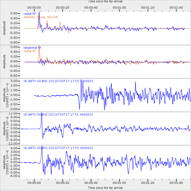
AMTX Amarillo, Texas, USA - Earthquake Result Viewer
*The percent match for this event was below the threshold and hence no stack was calculated.
| Earthquake location: |
Peru-Ecuador Border Region |
| Earthquake latitude/longitude: |
-4.9/-80.6 |
| Earthquake time(UTC): |
2021/07/30 (211) 17:10:19 GMT |
| Earthquake Depth: |
33 km |
| Earthquake Magnitude: |
6.2 Mww |
| Earthquake Catalog/Contributor: |
NEIC PDE/us |
|
| Network: |
US United States National Seismic Network |
| Station: |
AMTX Amarillo, Texas, USA |
| Lat/Lon: |
34.53 N/101.41 W |
| Elevation: |
1010 m |
|
| Distance: |
43.9 deg |
| Az: |
334.973 deg |
| Baz: |
149.301 deg |
| Ray Param: |
$rayparam |
*The percent match for this event was below the threshold and hence was not used in the summary stack. |
|
| Radial Match: |
90.68754 % |
| Radial Bump: |
400 |
| Transverse Match: |
85.226944 % |
| Transverse Bump: |
400 |
| SOD ConfigId: |
25131211 |
| Insert Time: |
2021-08-13 17:44:16.120 +0000 |
| GWidth: |
2.5 |
| Max Bumps: |
400 |
| Tol: |
0.001 |
|
Signal To Noise
| Channel | StoN | STA | LTA |
| US:AMTX:00:BHZ:20210730T17:17:55.499993Z | 13.247377 | 1.2126574E-6 | 9.1539434E-8 |
| US:AMTX:00:BH1:20210730T17:17:55.499993Z | 3.4091578 | 3.030257E-7 | 8.8885805E-8 |
| US:AMTX:00:BH2:20210730T17:17:55.499993Z | 2.8677347 | 2.6059988E-7 | 9.087308E-8 |
| Arrivals |
| Ps | |
| PpPs | |
| PsPs/PpSs | |


