You are here: Home > Network List > US - United States National Seismic Network Stations List
> Station BLA Blacksburg, Virginia, USA > Earthquake Result Viewer
BLA Blacksburg, Virginia, USA - Earthquake Result Viewer
| Earthquake location: |
Peru-Ecuador Border Region |
| Earthquake latitude/longitude: |
-4.9/-80.6 |
| Earthquake time(UTC): |
2021/07/30 (211) 17:10:19 GMT |
| Earthquake Depth: |
33 km |
| Earthquake Magnitude: |
6.2 Mww |
| Earthquake Catalog/Contributor: |
NEIC PDE/us |
|
| Network: |
US United States National Seismic Network |
| Station: |
BLA Blacksburg, Virginia, USA |
| Lat/Lon: |
37.21 N/80.42 W |
| Elevation: |
634 m |
|
| Distance: |
41.9 deg |
| Az: |
0.217 deg |
| Baz: |
180.27 deg |
| Ray Param: |
0.07341448 |
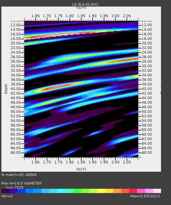
| Estimated Moho Depth: |
16.0 km |
| Estimated Crust Vp/Vs: |
1.75 |
| Assumed Crust Vp: |
6.159 km/s |
| Estimated Crust Vs: |
3.514 km/s |
| Estimated Crust Poisson's Ratio: |
0.26 |
|
| Radial Match: |
91.46564 % |
| Radial Bump: |
400 |
| Transverse Match: |
80.476585 % |
| Transverse Bump: |
400 |
| SOD ConfigId: |
25131211 |
| Insert Time: |
2021-08-13 17:44:18.987 +0000 |
| GWidth: |
2.5 |
| Max Bumps: |
400 |
| Tol: |
0.001 |
|

Signal To Noise
| Channel | StoN | STA | LTA |
| US:BLA:00:BHZ:20210730T17:17:36.349999Z | 31.29533 | 3.5261132E-6 | 1.1267218E-7 |
| US:BLA:00:BH1:20210730T17:17:36.349999Z | 20.353539 | 1.8625236E-6 | 9.150858E-8 |
| US:BLA:00:BH2:20210730T17:17:36.349999Z | 2.6218743 | 2.922446E-7 | 1.11464004E-7 |
| Arrivals |
| Ps | 2.1 SECOND |
| PpPs | 6.7 SECOND |
| PsPs/PpSs | 8.8 SECOND |


