You are here: Home > Network List > NM - Cooperative New Madrid Seismic Network Stations List
> Station BLO Bloomington, IN > Earthquake Result Viewer
BLO Bloomington, IN - Earthquake Result Viewer
| Earthquake location: |
Kuril Islands |
| Earthquake latitude/longitude: |
44.2/148.5 |
| Earthquake time(UTC): |
2001/06/24 (175) 13:18:51 GMT |
| Earthquake Depth: |
33 km |
| Earthquake Magnitude: |
5.8 MB, 5.7 MS, 6.0 MW |
| Earthquake Catalog/Contributor: |
WHDF/NEIC |
|
| Network: |
NM Cooperative New Madrid Seismic Network |
| Station: |
BLO Bloomington, IN |
| Lat/Lon: |
39.17 N/86.52 W |
| Elevation: |
246 m |
|
| Distance: |
83.3 deg |
| Az: |
39.894 deg |
| Baz: |
323.59 deg |
| Ray Param: |
0.046235286 |
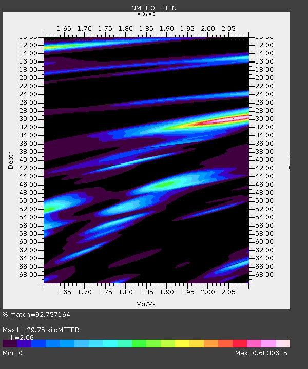
| Estimated Moho Depth: |
29.75 km |
| Estimated Crust Vp/Vs: |
2.06 |
| Assumed Crust Vp: |
6.444 km/s |
| Estimated Crust Vs: |
3.128 km/s |
| Estimated Crust Poisson's Ratio: |
0.35 |
|
| Radial Match: |
92.757164 % |
| Radial Bump: |
400 |
| Transverse Match: |
74.26249 % |
| Transverse Bump: |
400 |
| SOD ConfigId: |
4714 |
| Insert Time: |
2010-03-09 11:11:11.383 +0000 |
| GWidth: |
2.5 |
| Max Bumps: |
400 |
| Tol: |
0.001 |
|

Signal To Noise
| Channel | StoN | STA | LTA |
| NM:BLO: :BHN:20010624T13:30:44.048013Z | 1.8284763 | 1.03613E-7 | 5.666631E-8 |
| NM:BLO: :BHE:20010624T13:30:44.048013Z | 2.2833724 | 9.485974E-8 | 4.15437E-8 |
| NM:BLO: :BHZ:20010624T13:30:44.048013Z | 7.20333 | 4.660916E-7 | 6.470501E-8 |
| Arrivals |
| Ps | 5.0 SECOND |
| PpPs | 14 SECOND |
| PsPs/PpSs | 19 SECOND |


