You are here: Home > Network List > US - United States National Seismic Network Stations List
> Station NATX Nacogdoches, Texas, USA > Earthquake Result Viewer
NATX Nacogdoches, Texas, USA - Earthquake Result Viewer
| Earthquake location: |
Peru-Ecuador Border Region |
| Earthquake latitude/longitude: |
-4.9/-80.6 |
| Earthquake time(UTC): |
2021/07/30 (211) 17:10:19 GMT |
| Earthquake Depth: |
33 km |
| Earthquake Magnitude: |
6.2 Mww |
| Earthquake Catalog/Contributor: |
NEIC PDE/us |
|
| Network: |
US United States National Seismic Network |
| Station: |
NATX Nacogdoches, Texas, USA |
| Lat/Lon: |
31.76 N/94.66 W |
| Elevation: |
168 m |
|
| Distance: |
38.9 deg |
| Az: |
340.749 deg |
| Baz: |
157.316 deg |
| Ray Param: |
0.075273626 |
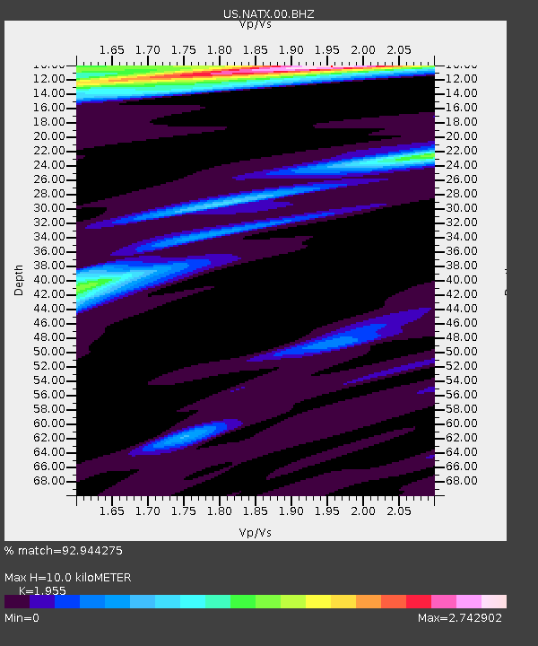
| Estimated Moho Depth: |
10.0 km |
| Estimated Crust Vp/Vs: |
1.96 |
| Assumed Crust Vp: |
5.738 km/s |
| Estimated Crust Vs: |
2.935 km/s |
| Estimated Crust Poisson's Ratio: |
0.32 |
|
| Radial Match: |
92.944275 % |
| Radial Bump: |
288 |
| Transverse Match: |
76.91394 % |
| Transverse Bump: |
400 |
| SOD ConfigId: |
25131211 |
| Insert Time: |
2021-08-13 17:45:03.610 +0000 |
| GWidth: |
2.5 |
| Max Bumps: |
400 |
| Tol: |
0.001 |
|

Signal To Noise
| Channel | StoN | STA | LTA |
| US:NATX:00:BHZ:20210730T17:17:11.123986Z | 27.338041 | 5.481351E-6 | 2.0050268E-7 |
| US:NATX:00:BH1:20210730T17:17:11.123986Z | 9.141296 | 2.05465E-6 | 2.2476571E-7 |
| US:NATX:00:BH2:20210730T17:17:11.123986Z | 6.5485997 | 1.3437078E-6 | 2.051901E-7 |
| Arrivals |
| Ps | 1.8 SECOND |
| PpPs | 4.9 SECOND |
| PsPs/PpSs | 6.6 SECOND |


