You are here: Home > Network List > US - United States National Seismic Network Stations List
> Station NLWA Neilton Lookout, Washington, USA > Earthquake Result Viewer
NLWA Neilton Lookout, Washington, USA - Earthquake Result Viewer
| Earthquake location: |
Peru-Ecuador Border Region |
| Earthquake latitude/longitude: |
-4.9/-80.6 |
| Earthquake time(UTC): |
2021/07/30 (211) 17:10:19 GMT |
| Earthquake Depth: |
33 km |
| Earthquake Magnitude: |
6.2 Mww |
| Earthquake Catalog/Contributor: |
NEIC PDE/us |
|
| Network: |
US United States National Seismic Network |
| Station: |
NLWA Neilton Lookout, Washington, USA |
| Lat/Lon: |
47.39 N/123.87 W |
| Elevation: |
640 m |
|
| Distance: |
64.5 deg |
| Az: |
328.944 deg |
| Baz: |
130.844 deg |
| Ray Param: |
0.058824234 |
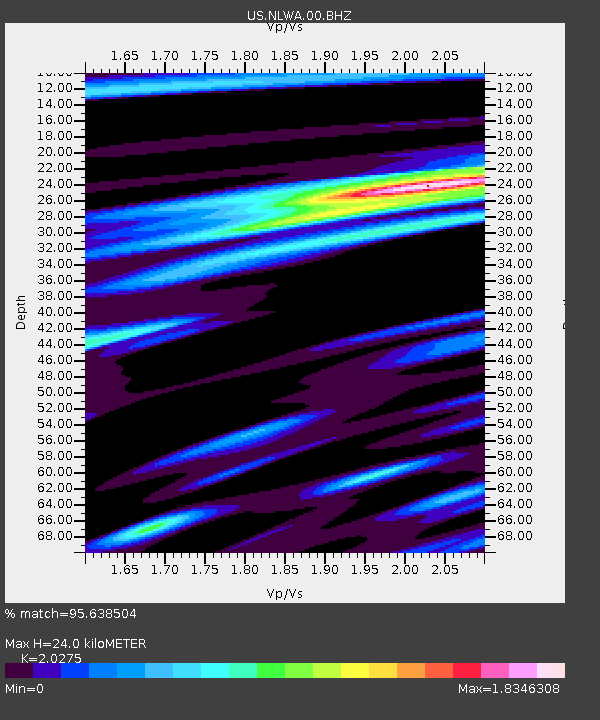
| Estimated Moho Depth: |
24.0 km |
| Estimated Crust Vp/Vs: |
2.03 |
| Assumed Crust Vp: |
6.566 km/s |
| Estimated Crust Vs: |
3.239 km/s |
| Estimated Crust Poisson's Ratio: |
0.34 |
|
| Radial Match: |
95.638504 % |
| Radial Bump: |
400 |
| Transverse Match: |
90.46209 % |
| Transverse Bump: |
400 |
| SOD ConfigId: |
25131211 |
| Insert Time: |
2021-08-13 17:45:08.604 +0000 |
| GWidth: |
2.5 |
| Max Bumps: |
400 |
| Tol: |
0.001 |
|
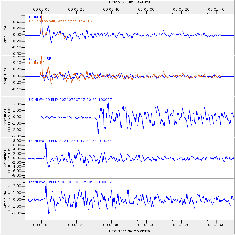
Signal To Noise
| Channel | StoN | STA | LTA |
| US:NLWA:00:BHZ:20210730T17:20:22.10003Z | 39.05189 | 3.1166715E-6 | 7.980846E-8 |
| US:NLWA:00:BH1:20210730T17:20:22.10003Z | 13.688462 | 1.0992177E-6 | 8.03025E-8 |
| US:NLWA:00:BH2:20210730T17:20:22.10003Z | 11.239087 | 1.0734882E-6 | 9.551382E-8 |
| Arrivals |
| Ps | 3.9 SECOND |
| PpPs | 11 SECOND |
| PsPs/PpSs | 15 SECOND |


