You are here: Home > Network List > NM - Cooperative New Madrid Seismic Network Stations List
> Station BLO Bloomington, IN > Earthquake Result Viewer
BLO Bloomington, IN - Earthquake Result Viewer
| Earthquake location: |
Near Coast Of Peru |
| Earthquake latitude/longitude: |
-16.1/-74.0 |
| Earthquake time(UTC): |
2001/07/05 (186) 13:53:48 GMT |
| Earthquake Depth: |
62 km |
| Earthquake Magnitude: |
6.2 MB, 6.6 MW, 6.5 ME |
| Earthquake Catalog/Contributor: |
WHDF/NEIC |
|
| Network: |
NM Cooperative New Madrid Seismic Network |
| Station: |
BLO Bloomington, IN |
| Lat/Lon: |
39.17 N/86.52 W |
| Elevation: |
246 m |
|
| Distance: |
56.2 deg |
| Az: |
348.287 deg |
| Baz: |
165.459 deg |
| Ray Param: |
0.06413282 |
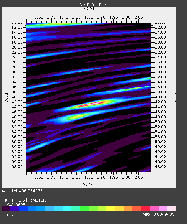
| Estimated Moho Depth: |
42.5 km |
| Estimated Crust Vp/Vs: |
1.86 |
| Assumed Crust Vp: |
6.444 km/s |
| Estimated Crust Vs: |
3.46 km/s |
| Estimated Crust Poisson's Ratio: |
0.30 |
|
| Radial Match: |
96.264275 % |
| Radial Bump: |
353 |
| Transverse Match: |
87.67196 % |
| Transverse Bump: |
400 |
| SOD ConfigId: |
4714 |
| Insert Time: |
2010-03-09 11:11:15.094 +0000 |
| GWidth: |
2.5 |
| Max Bumps: |
400 |
| Tol: |
0.001 |
|

Signal To Noise
| Channel | StoN | STA | LTA |
| NM:BLO: :BHN:20010705T14:02:51.398025Z | 4.0946455 | 4.077291E-7 | 9.957617E-8 |
| NM:BLO: :BHE:20010705T14:02:51.398025Z | 1.1733346 | 1.0927973E-7 | 9.313603E-8 |
| NM:BLO: :BHZ:20010705T14:02:51.398025Z | 9.634523 | 1.2102005E-6 | 1.2561082E-7 |
| Arrivals |
| Ps | 6.0 SECOND |
| PpPs | 18 SECOND |
| PsPs/PpSs | 24 SECOND |


