You are here: Home > Network List > UU - University of Utah Regional Network Stations List
> Station GAWY Genesis Alkali Granger, WY, USA > Earthquake Result Viewer
GAWY Genesis Alkali Granger, WY, USA - Earthquake Result Viewer
| Earthquake location: |
Peru-Ecuador Border Region |
| Earthquake latitude/longitude: |
-4.9/-80.6 |
| Earthquake time(UTC): |
2021/07/30 (211) 17:10:19 GMT |
| Earthquake Depth: |
33 km |
| Earthquake Magnitude: |
6.2 Mww |
| Earthquake Catalog/Contributor: |
NEIC PDE/us |
|
| Network: |
UU University of Utah Regional Network |
| Station: |
GAWY Genesis Alkali Granger, WY, USA |
| Lat/Lon: |
41.74 N/109.85 W |
| Elevation: |
2011 m |
|
| Distance: |
53.6 deg |
| Az: |
332.966 deg |
| Baz: |
142.763 deg |
| Ray Param: |
0.06596315 |
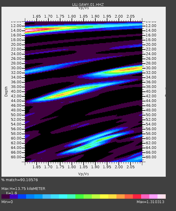
| Estimated Moho Depth: |
13.75 km |
| Estimated Crust Vp/Vs: |
1.60 |
| Assumed Crust Vp: |
6.207 km/s |
| Estimated Crust Vs: |
3.879 km/s |
| Estimated Crust Poisson's Ratio: |
0.18 |
|
| Radial Match: |
90.18576 % |
| Radial Bump: |
365 |
| Transverse Match: |
77.446686 % |
| Transverse Bump: |
399 |
| SOD ConfigId: |
25131211 |
| Insert Time: |
2021-08-13 17:45:46.860 +0000 |
| GWidth: |
2.5 |
| Max Bumps: |
400 |
| Tol: |
0.001 |
|

Signal To Noise
| Channel | StoN | STA | LTA |
| UU:GAWY:01:HHZ:20210730T17:19:06.359979Z | 49.73396 | 1.7056347E-7 | 3.4295173E-9 |
| UU:GAWY:01:HHN:20210730T17:19:06.359979Z | 15.4696245 | 4.3878387E-8 | 2.8364224E-9 |
| UU:GAWY:01:HHE:20210730T17:19:06.359979Z | 15.0054655 | 4.1571806E-8 | 2.770444E-9 |
| Arrivals |
| Ps | 1.4 SECOND |
| PpPs | 5.4 SECOND |
| PsPs/PpSs | 6.9 SECOND |


