You are here: Home > Network List > UU - University of Utah Regional Network Stations List
> Station PSUT Pine Spring, UT, USA > Earthquake Result Viewer
PSUT Pine Spring, UT, USA - Earthquake Result Viewer
| Earthquake location: |
Peru-Ecuador Border Region |
| Earthquake latitude/longitude: |
-4.9/-80.6 |
| Earthquake time(UTC): |
2021/07/30 (211) 17:10:19 GMT |
| Earthquake Depth: |
33 km |
| Earthquake Magnitude: |
6.2 Mww |
| Earthquake Catalog/Contributor: |
NEIC PDE/us |
|
| Network: |
UU University of Utah Regional Network |
| Station: |
PSUT Pine Spring, UT, USA |
| Lat/Lon: |
38.53 N/113.85 W |
| Elevation: |
1999 m |
|
| Distance: |
53.1 deg |
| Az: |
327.467 deg |
| Baz: |
136.906 deg |
| Ray Param: |
0.06627962 |
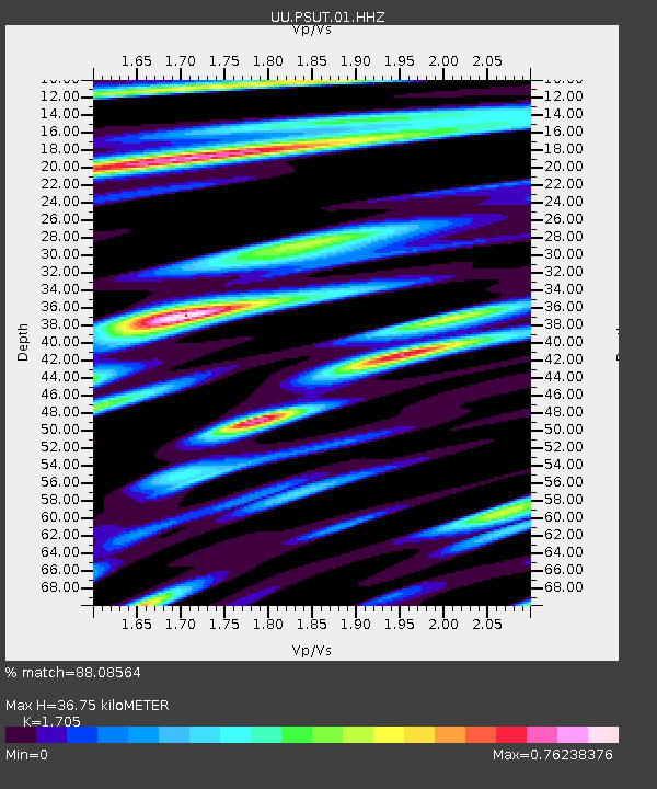
| Estimated Moho Depth: |
36.75 km |
| Estimated Crust Vp/Vs: |
1.71 |
| Assumed Crust Vp: |
6.276 km/s |
| Estimated Crust Vs: |
3.681 km/s |
| Estimated Crust Poisson's Ratio: |
0.24 |
|
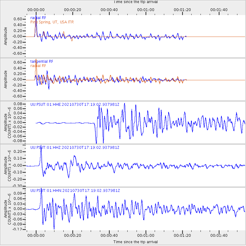
| Radial Match: |
88.08564 % |
| Radial Bump: |
389 |
| Transverse Match: |
85.37664 % |
| Transverse Bump: |
400 |
| SOD ConfigId: |
25131211 |
| Insert Time: |
2021-08-13 17:46:01.099 +0000 |
| GWidth: |
2.5 |
| Max Bumps: |
400 |
| Tol: |
0.001 |
|
Signal To Noise
| Channel | StoN | STA | LTA |
| UU:PSUT:01:HHZ:20210730T17:19:02.937981Z | 46.90317 | 1.00682975E-7 | 2.1466133E-9 |
| UU:PSUT:01:HHN:20210730T17:19:02.937981Z | 45.198624 | 4.596391E-8 | 1.0169316E-9 |
| UU:PSUT:01:HHE:20210730T17:19:02.937981Z | 23.656588 | 3.603809E-8 | 1.5233851E-9 |
| Arrivals |
| Ps | 4.4 SECOND |
| PpPs | 15 SECOND |
| PsPs/PpSs | 19 SECOND |


