You are here: Home > Network List > UU - University of Utah Regional Network Stations List
> Station VRUT Veyo Road, Veyo, UT, USA > Earthquake Result Viewer
VRUT Veyo Road, Veyo, UT, USA - Earthquake Result Viewer
| Earthquake location: |
Peru-Ecuador Border Region |
| Earthquake latitude/longitude: |
-4.9/-80.6 |
| Earthquake time(UTC): |
2021/07/30 (211) 17:10:19 GMT |
| Earthquake Depth: |
33 km |
| Earthquake Magnitude: |
6.2 Mww |
| Earthquake Catalog/Contributor: |
NEIC PDE/us |
|
| Network: |
UU University of Utah Regional Network |
| Station: |
VRUT Veyo Road, Veyo, UT, USA |
| Lat/Lon: |
37.46 N/113.86 W |
| Elevation: |
1874 m |
|
| Distance: |
52.3 deg |
| Az: |
326.542 deg |
| Baz: |
136.344 deg |
| Ray Param: |
0.06676604 |
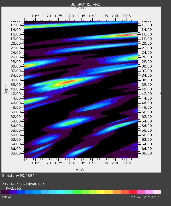
| Estimated Moho Depth: |
15.75 km |
| Estimated Crust Vp/Vs: |
2.10 |
| Assumed Crust Vp: |
6.194 km/s |
| Estimated Crust Vs: |
2.957 km/s |
| Estimated Crust Poisson's Ratio: |
0.35 |
|
| Radial Match: |
90.48844 % |
| Radial Bump: |
400 |
| Transverse Match: |
82.1433 % |
| Transverse Bump: |
400 |
| SOD ConfigId: |
25131211 |
| Insert Time: |
2021-08-13 17:46:15.140 +0000 |
| GWidth: |
2.5 |
| Max Bumps: |
400 |
| Tol: |
0.001 |
|

Signal To Noise
| Channel | StoN | STA | LTA |
| UU:VRUT:01:HHZ:20210730T17:18:57.210015Z | 81.38714 | 1.0854633E-7 | 1.3337038E-9 |
| UU:VRUT:01:HHN:20210730T17:18:57.210015Z | 23.650381 | 4.0614488E-8 | 1.7172869E-9 |
| UU:VRUT:01:HHE:20210730T17:18:57.210015Z | 16.067604 | 2.620713E-8 | 1.6310541E-9 |
| Arrivals |
| Ps | 2.9 SECOND |
| PpPs | 7.5 SECOND |
| PsPs/PpSs | 10 SECOND |


