You are here: Home > Network List > UW - Pacific Northwest Regional Seismic Network Stations List
> Station KENT Carlson Farm, Grass Valley, OR, USA > Earthquake Result Viewer
KENT Carlson Farm, Grass Valley, OR, USA - Earthquake Result Viewer
| Earthquake location: |
Peru-Ecuador Border Region |
| Earthquake latitude/longitude: |
-4.9/-80.6 |
| Earthquake time(UTC): |
2021/07/30 (211) 17:10:19 GMT |
| Earthquake Depth: |
33 km |
| Earthquake Magnitude: |
6.2 Mww |
| Earthquake Catalog/Contributor: |
NEIC PDE/us |
|
| Network: |
UW Pacific Northwest Regional Seismic Network |
| Station: |
KENT Carlson Farm, Grass Valley, OR, USA |
| Lat/Lon: |
45.24 N/120.64 W |
| Elevation: |
780 m |
|
| Distance: |
61.4 deg |
| Az: |
328.828 deg |
| Baz: |
133.124 deg |
| Ray Param: |
0.060837727 |
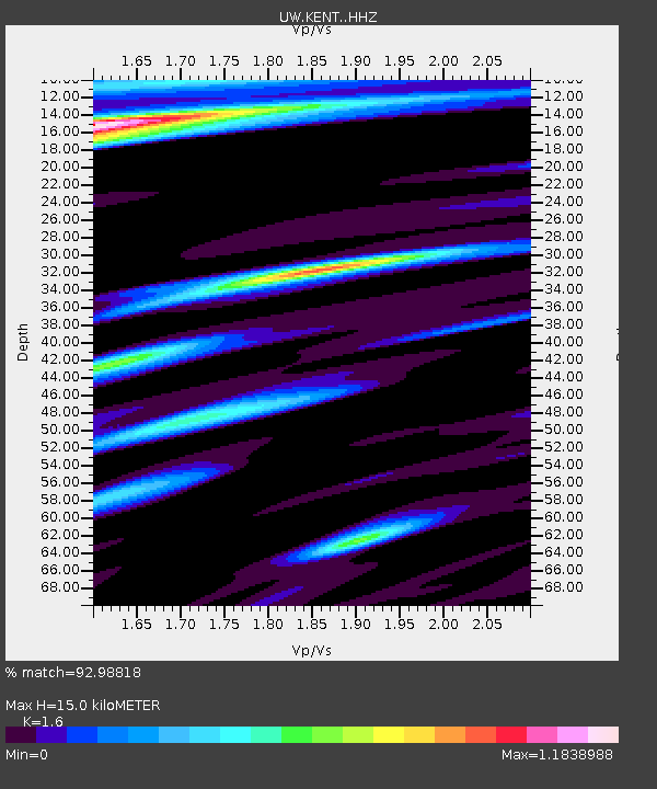
| Estimated Moho Depth: |
15.0 km |
| Estimated Crust Vp/Vs: |
1.60 |
| Assumed Crust Vp: |
6.597 km/s |
| Estimated Crust Vs: |
4.123 km/s |
| Estimated Crust Poisson's Ratio: |
0.18 |
|
| Radial Match: |
92.98818 % |
| Radial Bump: |
305 |
| Transverse Match: |
90.67379 % |
| Transverse Bump: |
400 |
| SOD ConfigId: |
25131211 |
| Insert Time: |
2021-08-13 17:47:08.773 +0000 |
| GWidth: |
2.5 |
| Max Bumps: |
400 |
| Tol: |
0.001 |
|
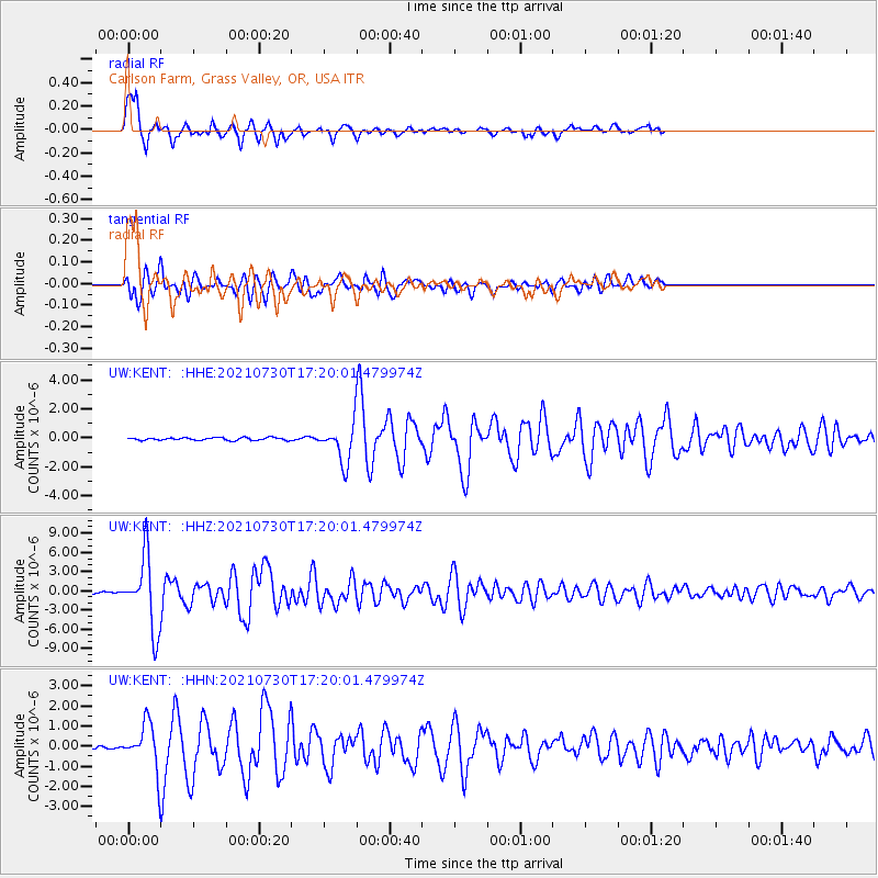
Signal To Noise
| Channel | StoN | STA | LTA |
| UW:KENT: :HHZ:20210730T17:20:01.479974Z | 55.57549 | 5.5697915E-6 | 1.00220284E-7 |
| UW:KENT: :HHN:20210730T17:20:01.479974Z | 8.782555 | 1.0816631E-6 | 1.2316042E-7 |
| UW:KENT: :HHE:20210730T17:20:01.479974Z | 13.994258 | 1.2656153E-6 | 9.0438185E-8 |
| Arrivals |
| Ps | 1.4 SECOND |
| PpPs | 5.6 SECOND |
| PsPs/PpSs | 7.0 SECOND |


