You are here: Home > Network List > UW - Pacific Northwest Regional Seismic Network Stations List
> Station LCCR Clarks, OR, USA > Earthquake Result Viewer
LCCR Clarks, OR, USA - Earthquake Result Viewer
*The percent match for this event was below the threshold and hence no stack was calculated.
| Earthquake location: |
Peru-Ecuador Border Region |
| Earthquake latitude/longitude: |
-4.9/-80.6 |
| Earthquake time(UTC): |
2021/07/30 (211) 17:10:19 GMT |
| Earthquake Depth: |
33 km |
| Earthquake Magnitude: |
6.2 Mww |
| Earthquake Catalog/Contributor: |
NEIC PDE/us |
|
| Network: |
UW Pacific Northwest Regional Seismic Network |
| Station: |
LCCR Clarks, OR, USA |
| Lat/Lon: |
45.21 N/122.48 W |
| Elevation: |
271 m |
|
| Distance: |
62.4 deg |
| Az: |
327.81 deg |
| Baz: |
131.34 deg |
| Ray Param: |
$rayparam |
*The percent match for this event was below the threshold and hence was not used in the summary stack. |
|
| Radial Match: |
74.91107 % |
| Radial Bump: |
400 |
| Transverse Match: |
66.34239 % |
| Transverse Bump: |
400 |
| SOD ConfigId: |
25131211 |
| Insert Time: |
2021-08-13 17:47:11.996 +0000 |
| GWidth: |
2.5 |
| Max Bumps: |
400 |
| Tol: |
0.001 |
|
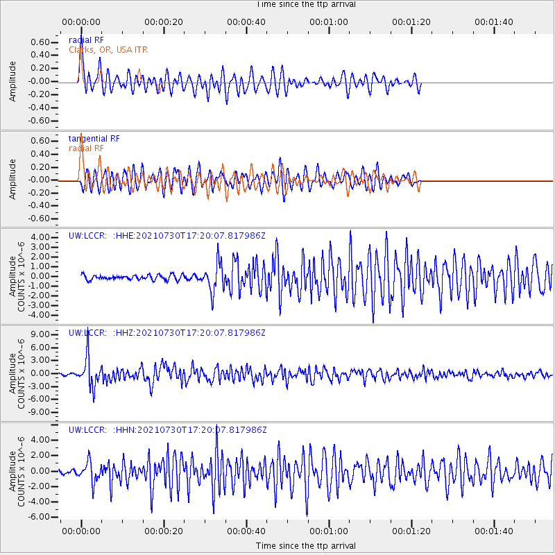
Signal To Noise
| Channel | StoN | STA | LTA |
| UW:LCCR: :HHZ:20210730T17:20:07.817986Z | 26.297632 | 3.4078585E-6 | 1.2958805E-7 |
| UW:LCCR: :HHN:20210730T17:20:07.817986Z | 7.2079124 | 1.3027421E-6 | 1.8073779E-7 |
| UW:LCCR: :HHE:20210730T17:20:07.817986Z | 6.133958 | 1.4834114E-6 | 2.4183592E-7 |
| Arrivals |
| Ps | |
| PpPs | |
| PsPs/PpSs | |


