You are here: Home > Network List > UW - Pacific Northwest Regional Seismic Network Stations List
> Station OTR Olympic Penninsula - Tyee Ridge, WA, USA > Earthquake Result Viewer
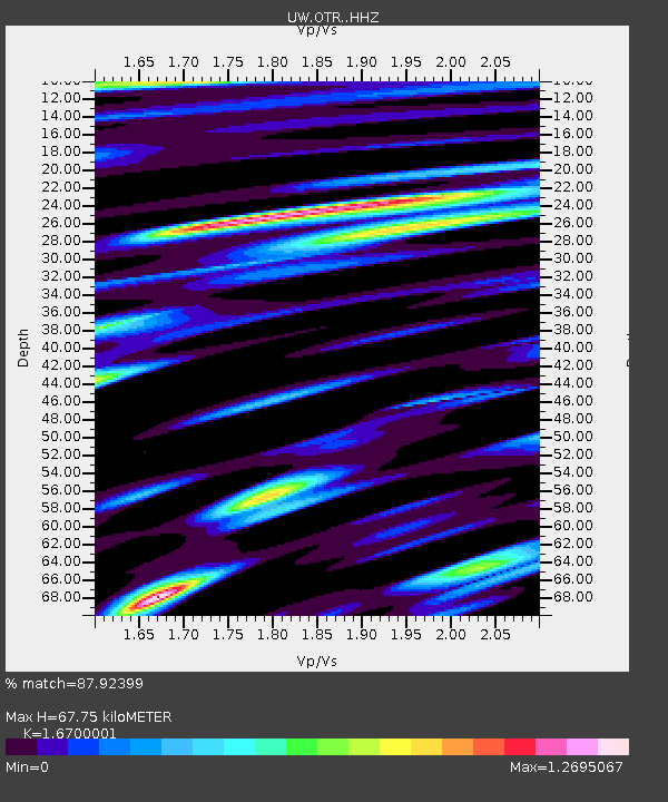
OTR Olympic Penninsula - Tyee Ridge, WA, USA - Earthquake Result Viewer
| Earthquake location: |
Peru-Ecuador Border Region |
| Earthquake latitude/longitude: |
-4.9/-80.6 |
| Earthquake time(UTC): |
2021/07/30 (211) 17:10:19 GMT |
| Earthquake Depth: |
33 km |
| Earthquake Magnitude: |
6.2 Mww |
| Earthquake Catalog/Contributor: |
NEIC PDE/us |
|
| Network: |
UW Pacific Northwest Regional Seismic Network |
| Station: |
OTR Olympic Penninsula - Tyee Ridge, WA, USA |
| Lat/Lon: |
48.09 N/124.35 W |
| Elevation: |
542 m |
|
| Distance: |
65.2 deg |
| Az: |
329.294 deg |
| Baz: |
130.642 deg |
| Ray Param: |
0.058369678 |
| Estimated Moho Depth: |
67.75 km |
| Estimated Crust Vp/Vs: |
1.67 |
| Assumed Crust Vp: |
6.391 km/s |
| Estimated Crust Vs: |
3.827 km/s |
| Estimated Crust Poisson's Ratio: |
0.22 |
|
| Radial Match: |
87.92399 % |
| Radial Bump: |
400 |
| Transverse Match: |
81.7633 % |
| Transverse Bump: |
400 |
| SOD ConfigId: |
25131211 |
| Insert Time: |
2021-08-13 17:47:39.354 +0000 |
| GWidth: |
2.5 |
| Max Bumps: |
400 |
| Tol: |
0.001 |
|

Signal To Noise
| Channel | StoN | STA | LTA |
| UW:OTR: :HHZ:20210730T17:20:26.609979Z | 21.191618 | 4.4730186E-6 | 2.1107489E-7 |
| UW:OTR: :HHN:20210730T17:20:26.609979Z | 2.63749 | 8.641102E-7 | 3.2762594E-7 |
| UW:OTR: :HHE:20210730T17:20:26.609979Z | 4.3998103 | 1.1294763E-6 | 2.5671025E-7 |
| Arrivals |
| Ps | 7.4 SECOND |
| PpPs | 27 SECOND |
| PsPs/PpSs | 35 SECOND |


