BUNG YL.BUNG - Earthquake Result Viewer
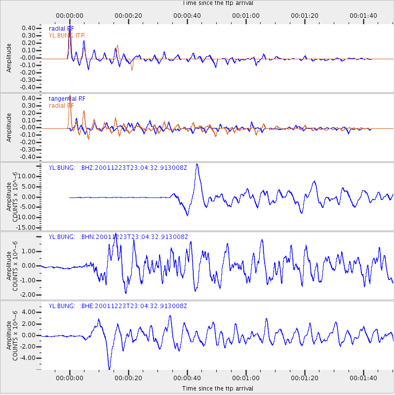
Earthquake location: Solomon Islands
Earthquake latitude/longitude: -9.6/159.5
Earthquake time(UTC): 2001/12/23 (357) 22:52:54 GMT
Earthquake Depth: 16 km
Earthquake Magnitude: 6.2 MB, 7.0 MS, 6.8 MW, 6.7 MW
Earthquake Catalog/Contributor: WHDF/NEIC
Network: YL Himalayan Nepal Tibet Experiment
Station: BUNG YL.BUNG
Lat/Lon: 27.88 N/85.89 E
Elevation: 1191 m
Distance: 80.3 deg
Az: 300.486 deg
Baz: 106.265 deg
Ray Param: 0.048369855
Estimated Moho Depth: 34.5 km
Estimated Crust Vp/Vs: 1.85
Assumed Crust Vp: 6.142 km/s
Estimated Crust Vs: 3.316 km/s
Estimated Crust Poisson's Ratio: 0.29
Radial Match: 93.39273 %
Radial Bump: 400
Transverse Match: 82.02327 %
Transverse Bump: 400
SOD ConfigId: 16820
Insert Time: 2010-02-26 15:51:05.449 +0000
GWidth: 2.5
Max Bumps: 400
Tol: 0.001

Signal To Noise

ChannelStoNSTALTA
YL:BUNG: :BHN:20011223T23:04:32.913008Z1.19281037.7488096E-86.4962634E-8
YL:BUNG: :BHE:20011223T23:04:32.913008Z1.32050748.8026916E-86.6661435E-8
YL:BUNG: :BHZ:20011223T23:04:32.913008Z2.80510192.7427845E-79.777843E-8
Arrivals
Ps4.9 SECOND
PpPs16 SECOND
PsPs/PpSs21 SECOND