You are here: Home > Network List > UW - Pacific Northwest Regional Seismic Network Stations List
> Station RVSD Chattaroy, WA, USA > Earthquake Result Viewer
RVSD Chattaroy, WA, USA - Earthquake Result Viewer
| Earthquake location: |
Peru-Ecuador Border Region |
| Earthquake latitude/longitude: |
-4.9/-80.6 |
| Earthquake time(UTC): |
2021/07/30 (211) 17:10:19 GMT |
| Earthquake Depth: |
33 km |
| Earthquake Magnitude: |
6.2 Mww |
| Earthquake Catalog/Contributor: |
NEIC PDE/us |
|
| Network: |
UW Pacific Northwest Regional Seismic Network |
| Station: |
RVSD Chattaroy, WA, USA |
| Lat/Lon: |
47.96 N/117.36 W |
| Elevation: |
611 m |
|
| Distance: |
61.8 deg |
| Az: |
332.838 deg |
| Baz: |
137.408 deg |
| Ray Param: |
0.060621846 |
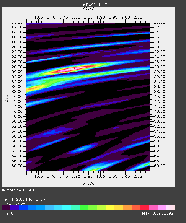
| Estimated Moho Depth: |
28.5 km |
| Estimated Crust Vp/Vs: |
1.79 |
| Assumed Crust Vp: |
6.571 km/s |
| Estimated Crust Vs: |
3.666 km/s |
| Estimated Crust Poisson's Ratio: |
0.27 |
|
| Radial Match: |
91.601 % |
| Radial Bump: |
369 |
| Transverse Match: |
80.311455 % |
| Transverse Bump: |
400 |
| SOD ConfigId: |
25131211 |
| Insert Time: |
2021-08-13 17:47:54.479 +0000 |
| GWidth: |
2.5 |
| Max Bumps: |
400 |
| Tol: |
0.001 |
|

Signal To Noise
| Channel | StoN | STA | LTA |
| UW:RVSD: :HHZ:20210730T17:20:03.820Z | 46.955498 | 2.7261863E-6 | 5.8058934E-8 |
| UW:RVSD: :HHN:20210730T17:20:03.820Z | 6.271345 | 9.366526E-7 | 1.4935434E-7 |
| UW:RVSD: :HHE:20210730T17:20:03.820Z | 4.9769044 | 9.460489E-7 | 1.9008782E-7 |
| Arrivals |
| Ps | 3.6 SECOND |
| PpPs | 12 SECOND |
| PsPs/PpSs | 15 SECOND |


