You are here: Home > Network List > UW - Pacific Northwest Regional Seismic Network Stations List
> Station SAW St. Andrews, WA, USA > Earthquake Result Viewer
SAW St. Andrews, WA, USA - Earthquake Result Viewer
| Earthquake location: |
Peru-Ecuador Border Region |
| Earthquake latitude/longitude: |
-4.9/-80.6 |
| Earthquake time(UTC): |
2021/07/30 (211) 17:10:19 GMT |
| Earthquake Depth: |
33 km |
| Earthquake Magnitude: |
6.2 Mww |
| Earthquake Catalog/Contributor: |
NEIC PDE/us |
|
| Network: |
UW Pacific Northwest Regional Seismic Network |
| Station: |
SAW St. Andrews, WA, USA |
| Lat/Lon: |
47.70 N/119.40 W |
| Elevation: |
701 m |
|
| Distance: |
62.5 deg |
| Az: |
331.505 deg |
| Baz: |
135.274 deg |
| Ray Param: |
0.060121316 |
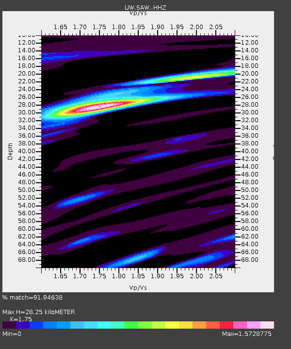
| Estimated Moho Depth: |
28.25 km |
| Estimated Crust Vp/Vs: |
1.75 |
| Assumed Crust Vp: |
6.419 km/s |
| Estimated Crust Vs: |
3.668 km/s |
| Estimated Crust Poisson's Ratio: |
0.26 |
|
| Radial Match: |
91.94638 % |
| Radial Bump: |
363 |
| Transverse Match: |
76.29058 % |
| Transverse Bump: |
400 |
| SOD ConfigId: |
25131211 |
| Insert Time: |
2021-08-13 17:47:57.367 +0000 |
| GWidth: |
2.5 |
| Max Bumps: |
400 |
| Tol: |
0.001 |
|

Signal To Noise
| Channel | StoN | STA | LTA |
| UW:SAW: :HHZ:20210730T17:20:08.910027Z | 50.2655 | 3.354741E-6 | 6.6740434E-8 |
| UW:SAW: :HHN:20210730T17:20:08.910027Z | 22.326572 | 1.0629681E-6 | 4.761E-8 |
| UW:SAW: :HHE:20210730T17:20:08.910027Z | 20.298697 | 1.2021168E-6 | 5.922138E-8 |
| Arrivals |
| Ps | 3.5 SECOND |
| PpPs | 12 SECOND |
| PsPs/PpSs | 15 SECOND |


