You are here: Home > Network List > NM - Cooperative New Madrid Seismic Network Stations List
> Station BLO Bloomington, IN > Earthquake Result Viewer
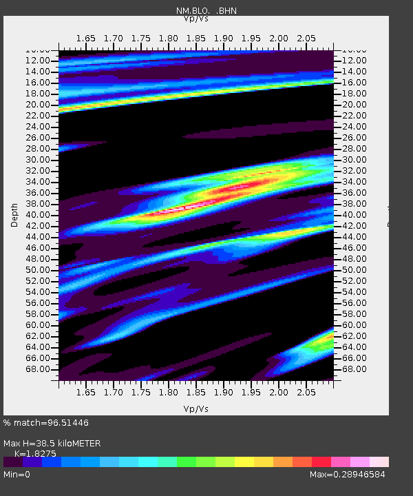
BLO Bloomington, IN - Earthquake Result Viewer
| Earthquake location: |
Kuril Islands |
| Earthquake latitude/longitude: |
46.0/151.5 |
| Earthquake time(UTC): |
2009/04/07 (097) 04:23:33 GMT |
| Earthquake Depth: |
31 km |
| Earthquake Magnitude: |
6.5 MB, 6.8 MS, 6.9 MW, 6.9 MW |
| Earthquake Catalog/Contributor: |
WHDF/NEIC |
|
| Network: |
NM Cooperative New Madrid Seismic Network |
| Station: |
BLO Bloomington, IN |
| Lat/Lon: |
39.17 N/86.52 W |
| Elevation: |
246 m |
|
| Distance: |
80.5 deg |
| Az: |
41.982 deg |
| Baz: |
323.18 deg |
| Ray Param: |
0.048196346 |
| Estimated Moho Depth: |
38.5 km |
| Estimated Crust Vp/Vs: |
1.83 |
| Assumed Crust Vp: |
6.444 km/s |
| Estimated Crust Vs: |
3.526 km/s |
| Estimated Crust Poisson's Ratio: |
0.29 |
|
| Radial Match: |
96.51446 % |
| Radial Bump: |
222 |
| Transverse Match: |
85.217285 % |
| Transverse Bump: |
400 |
| SOD ConfigId: |
2658 |
| Insert Time: |
2010-03-09 11:11:44.562 +0000 |
| GWidth: |
2.5 |
| Max Bumps: |
400 |
| Tol: |
0.001 |
|

Signal To Noise
| Channel | StoN | STA | LTA |
| NM:BLO: :BHN:20090407T04:35:10.941016Z | 18.323757 | 5.3367094E-6 | 2.9124536E-7 |
| NM:BLO: :BHE:20090407T04:35:10.941016Z | 6.8896155 | 1.5821973E-6 | 2.2964957E-7 |
| NM:BLO: :BHZ:20090407T04:35:10.941016Z | 6.8837504 | 1.2626763E-6 | 1.8342854E-7 |
| Arrivals |
| Ps | 5.1 SECOND |
| PpPs | 16 SECOND |
| PsPs/PpSs | 22 SECOND |


