You are here: Home > Network List > YX16 - Raton Basin UNM Broadband Network Stations List
> Station UNM4 NW Corner of NM Stations > Earthquake Result Viewer
UNM4 NW Corner of NM Stations - Earthquake Result Viewer
| Earthquake location: |
Peru-Ecuador Border Region |
| Earthquake latitude/longitude: |
-4.9/-80.6 |
| Earthquake time(UTC): |
2021/07/30 (211) 17:10:19 GMT |
| Earthquake Depth: |
33 km |
| Earthquake Magnitude: |
6.2 Mww |
| Earthquake Catalog/Contributor: |
NEIC PDE/us |
|
| Network: |
YX Raton Basin UNM Broadband Network |
| Station: |
UNM4 NW Corner of NM Stations |
| Lat/Lon: |
36.99 N/105.06 W |
| Elevation: |
2784 m |
|
| Distance: |
47.5 deg |
| Az: |
333.308 deg |
| Baz: |
146.014 deg |
| Ray Param: |
0.069870844 |
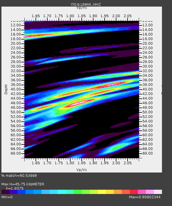
| Estimated Moho Depth: |
45.75 km |
| Estimated Crust Vp/Vs: |
1.84 |
| Assumed Crust Vp: |
6.316 km/s |
| Estimated Crust Vs: |
3.437 km/s |
| Estimated Crust Poisson's Ratio: |
0.29 |
|
| Radial Match: |
90.53669 % |
| Radial Bump: |
310 |
| Transverse Match: |
70.966156 % |
| Transverse Bump: |
400 |
| SOD ConfigId: |
25131211 |
| Insert Time: |
2021-08-13 17:49:51.433 +0000 |
| GWidth: |
2.5 |
| Max Bumps: |
400 |
| Tol: |
0.001 |
|

Signal To Noise
| Channel | StoN | STA | LTA |
| YX:UNM4: :HHZ:20210730T17:18:21.040002Z | 48.913586 | 4.118085E-6 | 8.419103E-8 |
| YX:UNM4: :HHN:20210730T17:18:21.040002Z | 15.552611 | 1.4069607E-6 | 9.046459E-8 |
| YX:UNM4: :HHE:20210730T17:18:21.040002Z | 12.589006 | 1.017699E-6 | 8.08403E-8 |
| Arrivals |
| Ps | 6.4 SECOND |
| PpPs | 19 SECOND |
| PsPs/PpSs | 26 SECOND |


