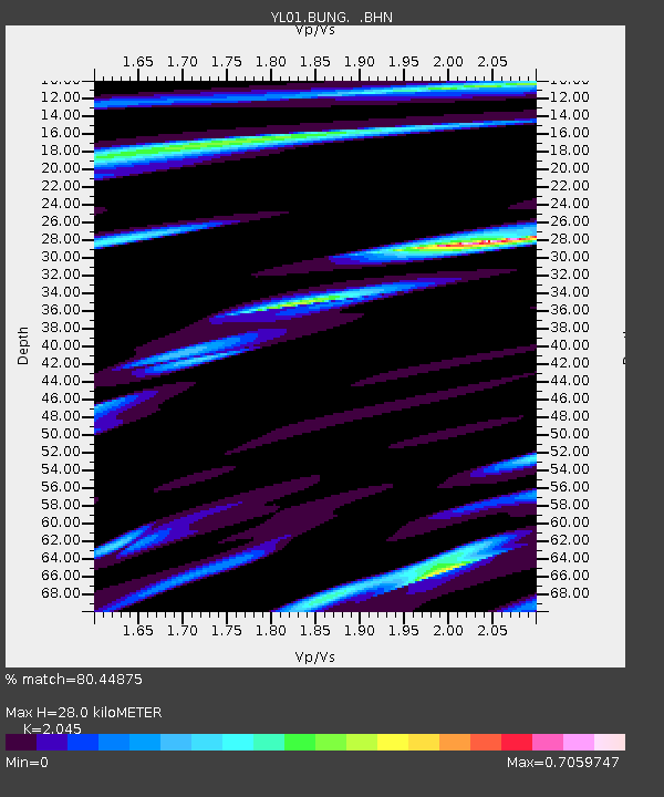
BUNG YL.BUNG - Earthquake Result Viewer
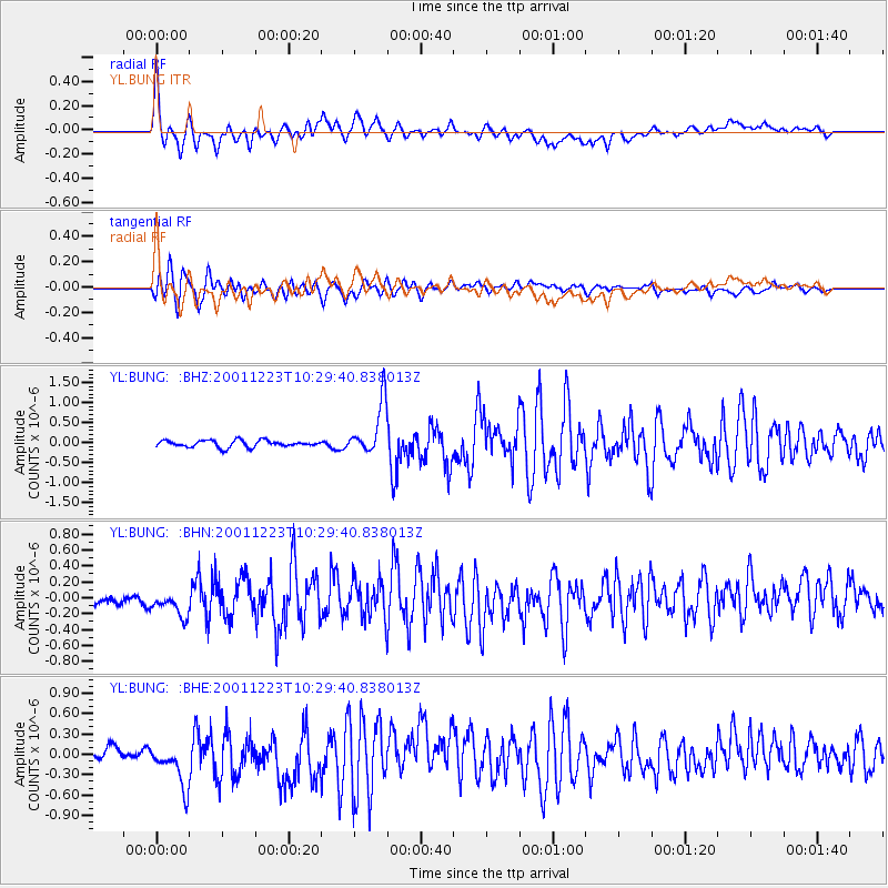
Earthquake location: Bonin Islands, Japan Region
Earthquake latitude/longitude: 27.9/141.8
Earthquake time(UTC): 2001/12/23 (357) 10:21:28 GMT
Earthquake Depth: 35 km
Earthquake Magnitude: 5.7 MB, 5.6 MS, 5.9 MW, 5.8 MW
Earthquake Catalog/Contributor: WHDF/NEIC
Network: YL Himalayan Nepal Tibet Experiment
Station: BUNG YL.BUNG
Lat/Lon: 27.88 N/85.89 E
Elevation: 1191 m
Distance: 49.0 deg
Az: 283.857 deg
Baz: 76.156 deg
Ray Param: 0.06891657
Estimated Moho Depth: 28.0 km
Estimated Crust Vp/Vs: 2.05
Assumed Crust Vp: 6.142 km/s
Estimated Crust Vs: 3.003 km/s
Estimated Crust Poisson's Ratio: 0.34
Radial Match: 80.44875 %
Radial Bump: 400
Transverse Match: 78.06033 %
Transverse Bump: 400
SOD ConfigId: 16820
Insert Time: 2010-02-26 15:51:06.466 +0000
GWidth: 2.5
Max Bumps: 400
Tol: 0.001

Signal To Noise

ChannelStoNSTALTA
YL:BUNG: :BHN:20011223T10:29:40.838013Z1.76676112.2215195E-71.2573967E-7
YL:BUNG: :BHE:20011223T10:29:40.838013Z3.62472723.766186E-71.039026E-7
YL:BUNG: :BHZ:20011223T10:29:40.838013Z7.80060636.553936E-78.401829E-8
Arrivals
Ps5.0 SECOND
PpPs13 SECOND
PsPs/PpSs18 SECOND