You are here: Home > Network List > UU - University of Utah Regional Network Stations List
> Station HMU Henry Mountain, UT, USA > Earthquake Result Viewer
HMU Henry Mountain, UT, USA - Earthquake Result Viewer
| Earthquake location: |
Komandorskiye Ostrova Region |
| Earthquake latitude/longitude: |
55.4/166.5 |
| Earthquake time(UTC): |
2018/01/25 (025) 02:10:33 GMT |
| Earthquake Depth: |
8.8 km |
| Earthquake Magnitude: |
6.2 Mww |
| Earthquake Catalog/Contributor: |
NEIC PDE/us |
|
| Network: |
UU University of Utah Regional Network |
| Station: |
HMU Henry Mountain, UT, USA |
| Lat/Lon: |
37.94 N/110.74 W |
| Elevation: |
2430 m |
|
| Distance: |
56.0 deg |
| Az: |
71.163 deg |
| Baz: |
316.941 deg |
| Ray Param: |
0.06444623 |
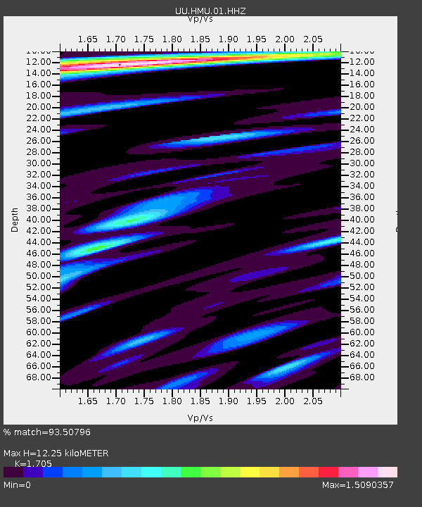
| Estimated Moho Depth: |
12.25 km |
| Estimated Crust Vp/Vs: |
1.71 |
| Assumed Crust Vp: |
6.247 km/s |
| Estimated Crust Vs: |
3.664 km/s |
| Estimated Crust Poisson's Ratio: |
0.24 |
|
| Radial Match: |
93.50796 % |
| Radial Bump: |
400 |
| Transverse Match: |
87.74223 % |
| Transverse Bump: |
400 |
| SOD ConfigId: |
2546091 |
| Insert Time: |
2018-02-08 02:17:23.499 +0000 |
| GWidth: |
2.5 |
| Max Bumps: |
400 |
| Tol: |
0.001 |
|

Signal To Noise
| Channel | StoN | STA | LTA |
| UU:HMU:01:HHZ:20180125T02:19:41.127993Z | 3.1489413 | 1.3302208E-8 | 4.224343E-9 |
| UU:HMU:01:HHN:20180125T02:19:41.127993Z | 1.097538 | 6.171354E-9 | 5.622907E-9 |
| UU:HMU:01:HHE:20180125T02:19:41.127993Z | 1.6422514 | 7.919515E-9 | 4.8223527E-9 |
| Arrivals |
| Ps | 1.5 SECOND |
| PpPs | 5.0 SECOND |
| PsPs/PpSs | 6.5 SECOND |


