You are here: Home > Network List > UU - University of Utah Regional Network Stations List
> Station MPU Maple Canyon, UT, USA > Earthquake Result Viewer
MPU Maple Canyon, UT, USA - Earthquake Result Viewer
| Earthquake location: |
Komandorskiye Ostrova Region |
| Earthquake latitude/longitude: |
55.4/166.5 |
| Earthquake time(UTC): |
2018/01/25 (025) 02:10:33 GMT |
| Earthquake Depth: |
8.8 km |
| Earthquake Magnitude: |
6.2 Mww |
| Earthquake Catalog/Contributor: |
NEIC PDE/us |
|
| Network: |
UU University of Utah Regional Network |
| Station: |
MPU Maple Canyon, UT, USA |
| Lat/Lon: |
40.02 N/111.63 W |
| Elevation: |
1909 m |
|
| Distance: |
54.0 deg |
| Az: |
70.028 deg |
| Baz: |
315.731 deg |
| Ray Param: |
0.06572978 |
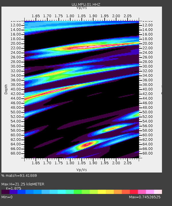
| Estimated Moho Depth: |
21.25 km |
| Estimated Crust Vp/Vs: |
1.88 |
| Assumed Crust Vp: |
6.155 km/s |
| Estimated Crust Vs: |
3.283 km/s |
| Estimated Crust Poisson's Ratio: |
0.30 |
|
| Radial Match: |
93.41889 % |
| Radial Bump: |
400 |
| Transverse Match: |
84.62354 % |
| Transverse Bump: |
400 |
| SOD ConfigId: |
2546091 |
| Insert Time: |
2018-02-08 02:17:29.511 +0000 |
| GWidth: |
2.5 |
| Max Bumps: |
400 |
| Tol: |
0.001 |
|

Signal To Noise
| Channel | StoN | STA | LTA |
| UU:MPU:01:HHZ:20180125T02:19:26.815005Z | 2.1015747 | 1.21830315E-8 | 5.7970966E-9 |
| UU:MPU:01:HHN:20180125T02:19:26.815005Z | 0.62470335 | 3.1149703E-9 | 4.9863194E-9 |
| UU:MPU:01:HHE:20180125T02:19:26.815005Z | 3.645655 | 1.2229649E-8 | 3.3545822E-9 |
| Arrivals |
| Ps | 3.2 SECOND |
| PpPs | 9.5 SECOND |
| PsPs/PpSs | 13 SECOND |


