You are here: Home > Network List > UU - University of Utah Regional Network Stations List
> Station RDMU Red Mountain, UT, USA > Earthquake Result Viewer
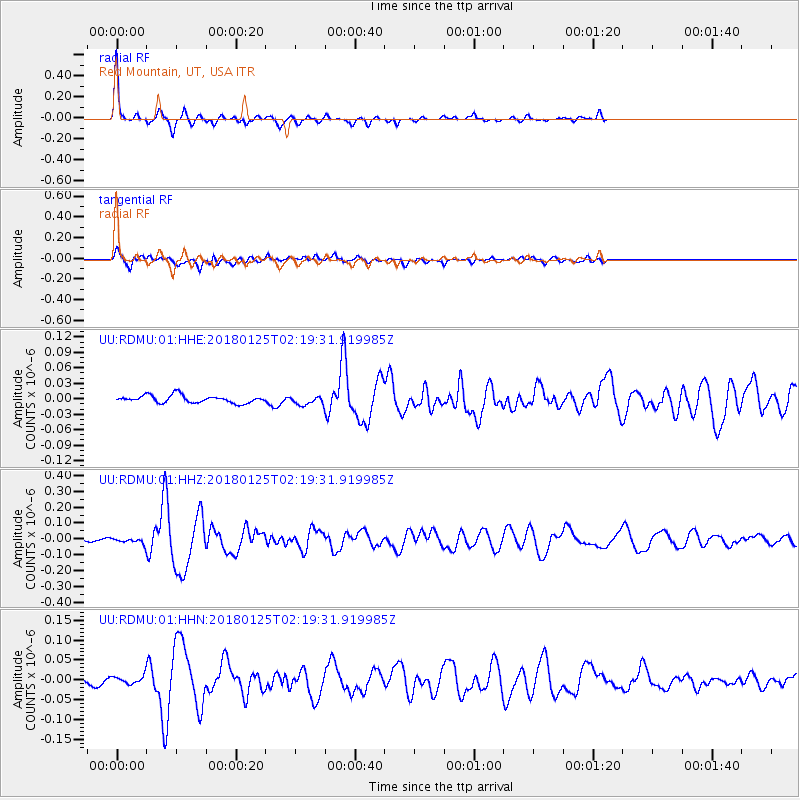
RDMU Red Mountain, UT, USA - Earthquake Result Viewer

| Earthquake location: |
Komandorskiye Ostrova Region |
| Earthquake latitude/longitude: |
55.4/166.5 |
| Earthquake time(UTC): |
2018/01/25 (025) 02:10:33 GMT |
| Earthquake Depth: |
8.8 km |
| Earthquake Magnitude: |
6.2 Mww |
| Earthquake Catalog/Contributor: |
NEIC PDE/us |
|
| Network: |
UU University of Utah Regional Network |
| Station: |
RDMU Red Mountain, UT, USA |
| Lat/Lon: |
40.57 N/109.57 W |
| Elevation: |
2087 m |
|
| Distance: |
54.7 deg |
| Az: |
68.159 deg |
| Baz: |
315.97 deg |
| Ray Param: |
0.065289505 |
| Estimated Moho Depth: |
56.0 km |
| Estimated Crust Vp/Vs: |
1.75 |
| Assumed Crust Vp: |
6.207 km/s |
| Estimated Crust Vs: |
3.547 km/s |
| Estimated Crust Poisson's Ratio: |
0.26 |
|
| Radial Match: |
95.68606 % |
| Radial Bump: |
266 |
| Transverse Match: |
76.84678 % |
| Transverse Bump: |
400 |
| SOD ConfigId: |
2546091 |
| Insert Time: |
2018-02-08 02:17:36.468 +0000 |
| GWidth: |
2.5 |
| Max Bumps: |
400 |
| Tol: |
0.001 |
|
Signal To Noise
| Channel | StoN | STA | LTA |
| UU:RDMU:01:HHZ:20180125T02:19:31.919985Z | 2.0894737 | 1.5618319E-8 | 7.474762E-9 |
| UU:RDMU:01:HHN:20180125T02:19:31.919985Z | 1.4725169 | 9.190427E-9 | 6.2413053E-9 |
| UU:RDMU:01:HHE:20180125T02:19:31.919985Z | 1.1646073 | 8.38319E-9 | 7.1982975E-9 |
| Arrivals |
| Ps | 7.1 SECOND |
| PpPs | 24 SECOND |
| PsPs/PpSs | 31 SECOND |


