You are here: Home > Network List > UU - University of Utah Regional Network Stations List
> Station TCU Toone Canyon, UT, USA > Earthquake Result Viewer
TCU Toone Canyon, UT, USA - Earthquake Result Viewer
| Earthquake location: |
Komandorskiye Ostrova Region |
| Earthquake latitude/longitude: |
55.4/166.5 |
| Earthquake time(UTC): |
2018/01/25 (025) 02:10:33 GMT |
| Earthquake Depth: |
8.8 km |
| Earthquake Magnitude: |
6.2 Mww |
| Earthquake Catalog/Contributor: |
NEIC PDE/us |
|
| Network: |
UU University of Utah Regional Network |
| Station: |
TCU Toone Canyon, UT, USA |
| Lat/Lon: |
41.12 N/111.41 W |
| Elevation: |
2269 m |
|
| Distance: |
53.3 deg |
| Az: |
68.918 deg |
| Baz: |
315.219 deg |
| Ray Param: |
0.06617523 |
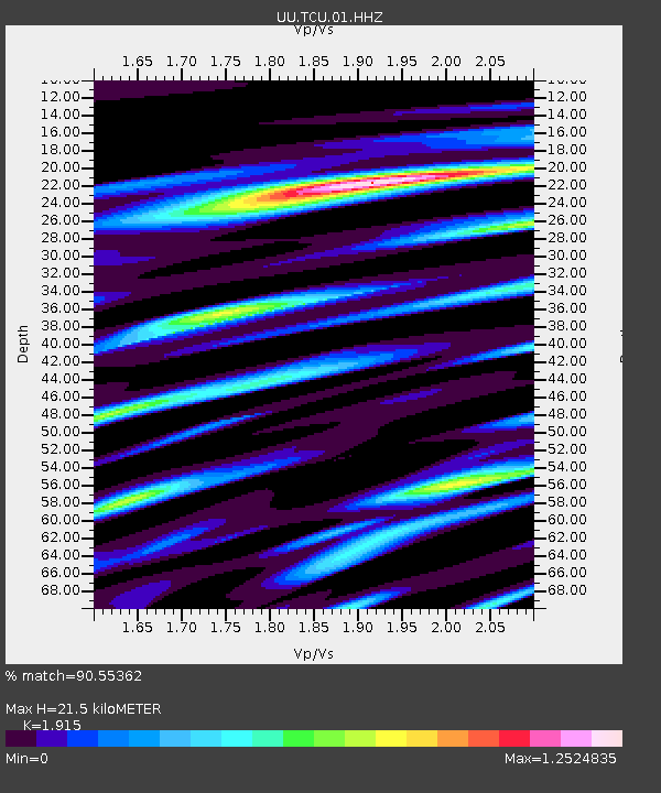
| Estimated Moho Depth: |
21.5 km |
| Estimated Crust Vp/Vs: |
1.91 |
| Assumed Crust Vp: |
6.155 km/s |
| Estimated Crust Vs: |
3.214 km/s |
| Estimated Crust Poisson's Ratio: |
0.31 |
|
| Radial Match: |
90.55362 % |
| Radial Bump: |
400 |
| Transverse Match: |
78.55943 % |
| Transverse Bump: |
400 |
| SOD ConfigId: |
2546091 |
| Insert Time: |
2018-02-08 02:17:42.585 +0000 |
| GWidth: |
2.5 |
| Max Bumps: |
400 |
| Tol: |
0.001 |
|

Signal To Noise
| Channel | StoN | STA | LTA |
| UU:TCU:01:HHZ:20180125T02:19:21.960024Z | 3.0219412 | 1.4009545E-8 | 4.6359423E-9 |
| UU:TCU:01:HHN:20180125T02:19:21.960024Z | 1.1508857 | 1.0320955E-8 | 8.967837E-9 |
| UU:TCU:01:HHE:20180125T02:19:21.960024Z | 0.812856 | 9.076234E-9 | 1.1165858E-8 |
| Arrivals |
| Ps | 3.3 SECOND |
| PpPs | 9.7 SECOND |
| PsPs/PpSs | 13 SECOND |


