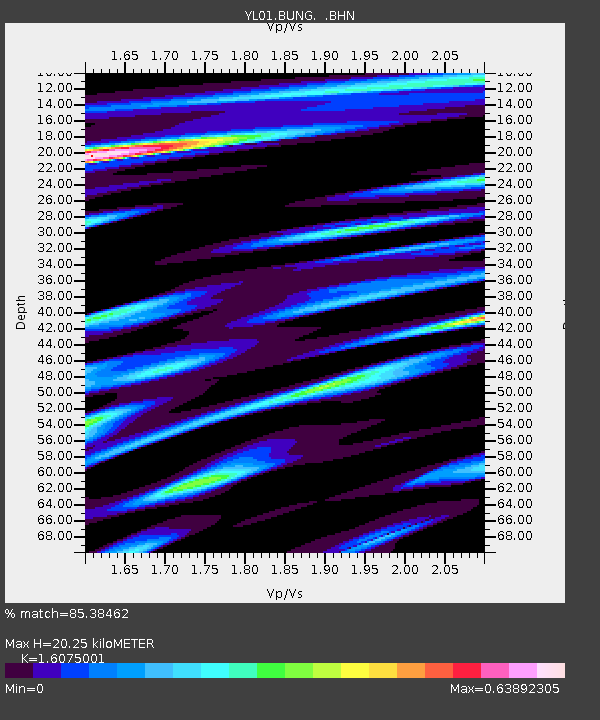
BUNG YL.BUNG - Earthquake Result Viewer

Earthquake location: Ryukyu Islands, Japan
Earthquake latitude/longitude: 28.3/129.6
Earthquake time(UTC): 2001/12/08 (342) 20:29:34 GMT
Earthquake Depth: 33 km
Earthquake Magnitude: 5.7 MB, 5.7 MS, 6.2 MW, 6.1 MW
Earthquake Catalog/Contributor: WHDF/NEIC
Network: YL Himalayan Nepal Tibet Experiment
Station: BUNG YL.BUNG
Lat/Lon: 27.88 N/85.89 E
Elevation: 1191 m
Distance: 38.4 deg
Az: 280.098 deg
Baz: 78.85 deg
Ray Param: 0.07552483
Estimated Moho Depth: 20.25 km
Estimated Crust Vp/Vs: 1.61
Assumed Crust Vp: 6.142 km/s
Estimated Crust Vs: 3.821 km/s
Estimated Crust Poisson's Ratio: 0.18
Radial Match: 85.38462 %
Radial Bump: 332
Transverse Match: 76.54372 %
Transverse Bump: 400
SOD ConfigId: 16820
Insert Time: 2010-02-26 15:51:09.703 +0000
GWidth: 2.5
Max Bumps: 400
Tol: 0.001

Signal To Noise

ChannelStoNSTALTA
YL:BUNG: :BHN:20011208T20:36:21.986012Z6.9808263.0905977E-74.4272664E-8
YL:BUNG: :BHE:20011208T20:36:21.986012Z6.24491076.2150605E-79.9522005E-8
YL:BUNG: :BHZ:20011208T20:36:21.986012Z15.750521.246627E-67.914831E-8
Arrivals
Ps2.2 SECOND
PpPs8.0 SECOND
PsPs/PpSs10 SECOND