You are here: Home > Network List > GS - US Geological Survey Networks Stations List
> Station KAN10 Keim Farm > Earthquake Result Viewer
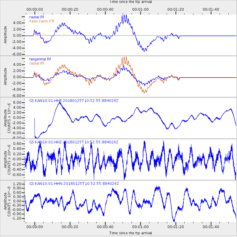
KAN10 Keim Farm - Earthquake Result Viewer
*The percent match for this event was below the threshold and hence no stack was calculated.
| Earthquake location: |
Fiji Islands Region |
| Earthquake latitude/longitude: |
-17.8/-179.6 |
| Earthquake time(UTC): |
2018/01/25 (025) 10:41:14 GMT |
| Earthquake Depth: |
621 km |
| Earthquake Magnitude: |
5.7 Mww |
| Earthquake Catalog/Contributor: |
NEIC PDE/us |
|
| Network: |
GS US Geological Survey Networks |
| Station: |
KAN10 Keim Farm |
| Lat/Lon: |
37.12 N/98.10 W |
| Elevation: |
417 m |
|
| Distance: |
94.0 deg |
| Az: |
52.425 deg |
| Baz: |
250.899 deg |
| Ray Param: |
$rayparam |
*The percent match for this event was below the threshold and hence was not used in the summary stack. |
|
| Radial Match: |
73.39175 % |
| Radial Bump: |
400 |
| Transverse Match: |
67.39166 % |
| Transverse Bump: |
400 |
| SOD ConfigId: |
2546091 |
| Insert Time: |
2018-02-08 10:42:13.820 +0000 |
| GWidth: |
2.5 |
| Max Bumps: |
400 |
| Tol: |
0.001 |
|
Signal To Noise
| Channel | StoN | STA | LTA |
| GS:KAN10:01:HHZ:20180125T10:52:55.884026Z | 1.0242466 | 3.2806548E-7 | 3.202993E-7 |
| GS:KAN10:01:HHN:20180125T10:52:55.884026Z | 0.36656472 | 3.0712525E-7 | 8.3784727E-7 |
| GS:KAN10:01:HHE:20180125T10:52:55.884026Z | 0.29463163 | 1.248704E-6 | 4.238187E-6 |
| Arrivals |
| Ps | |
| PpPs | |
| PsPs/PpSs | |


