You are here: Home > Network List > IU - Global Seismograph Network (GSN - IRIS/USGS) Stations List
> Station PMG Port Moresby, New Guinea > Earthquake Result Viewer
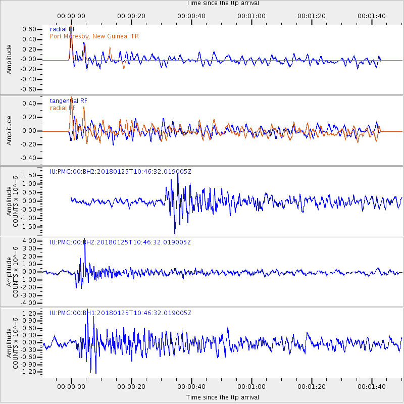
PMG Port Moresby, New Guinea - Earthquake Result Viewer
*The percent match for this event was below the threshold and hence no stack was calculated.
| Earthquake location: |
Fiji Islands Region |
| Earthquake latitude/longitude: |
-17.8/-179.6 |
| Earthquake time(UTC): |
2018/01/25 (025) 10:41:14 GMT |
| Earthquake Depth: |
621 km |
| Earthquake Magnitude: |
5.7 Mww |
| Earthquake Catalog/Contributor: |
NEIC PDE/us |
|
| Network: |
IU Global Seismograph Network (GSN - IRIS/USGS) |
| Station: |
PMG Port Moresby, New Guinea |
| Lat/Lon: |
9.40 S/147.16 E |
| Elevation: |
90 m |
|
| Distance: |
33.3 deg |
| Az: |
280.033 deg |
| Baz: |
108.011 deg |
| Ray Param: |
$rayparam |
*The percent match for this event was below the threshold and hence was not used in the summary stack. |
|
| Radial Match: |
73.15411 % |
| Radial Bump: |
400 |
| Transverse Match: |
60.583496 % |
| Transverse Bump: |
400 |
| SOD ConfigId: |
2546091 |
| Insert Time: |
2018-02-08 10:42:40.580 +0000 |
| GWidth: |
2.5 |
| Max Bumps: |
400 |
| Tol: |
0.001 |
|
Signal To Noise
| Channel | StoN | STA | LTA |
| IU:PMG:00:BHZ:20180125T10:46:32.019005Z | 8.123479 | 1.2847005E-6 | 1.5814658E-7 |
| IU:PMG:00:BH1:20180125T10:46:32.019005Z | 1.6632218 | 2.2596089E-7 | 1.3585733E-7 |
| IU:PMG:00:BH2:20180125T10:46:32.019005Z | 5.6400504 | 6.4341515E-7 | 1.1407969E-7 |
| Arrivals |
| Ps | |
| PpPs | |
| PsPs/PpSs | |


