You are here: Home > Network List > US - United States National Seismic Network Stations List
> Station HAWA Hanford, Washington, USA > Earthquake Result Viewer
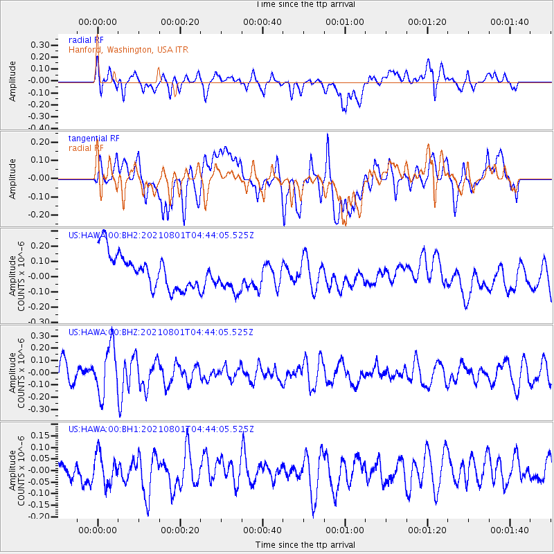
HAWA Hanford, Washington, USA - Earthquake Result Viewer
*The percent match for this event was below the threshold and hence no stack was calculated.
| Earthquake location: |
Dodecanese Islands, Greece |
| Earthquake latitude/longitude: |
36.4/27.0 |
| Earthquake time(UTC): |
2021/08/01 (213) 04:31:27 GMT |
| Earthquake Depth: |
11 km |
| Earthquake Magnitude: |
5.7 mww |
| Earthquake Catalog/Contributor: |
NEIC PDE/us |
|
| Network: |
US United States National Seismic Network |
| Station: |
HAWA Hanford, Washington, USA |
| Lat/Lon: |
46.39 N/119.53 W |
| Elevation: |
364 m |
|
| Distance: |
92.3 deg |
| Az: |
337.557 deg |
| Baz: |
26.427 deg |
| Ray Param: |
$rayparam |
*The percent match for this event was below the threshold and hence was not used in the summary stack. |
|
| Radial Match: |
55.75995 % |
| Radial Bump: |
400 |
| Transverse Match: |
37.394398 % |
| Transverse Bump: |
400 |
| SOD ConfigId: |
25131211 |
| Insert Time: |
2021-08-15 04:53:38.149 +0000 |
| GWidth: |
2.5 |
| Max Bumps: |
400 |
| Tol: |
0.001 |
|
Signal To Noise
| Channel | StoN | STA | LTA |
| US:HAWA:00:BHZ:20210801T04:44:05.525Z | 2.3661656 | 2.0260173E-7 | 8.5624485E-8 |
| US:HAWA:00:BH1:20210801T04:44:05.525Z | 1.600815 | 6.597905E-8 | 4.121591E-8 |
| US:HAWA:00:BH2:20210801T04:44:05.525Z | 0.98105216 | 1.14477714E-7 | 1.1668871E-7 |
| Arrivals |
| Ps | |
| PpPs | |
| PsPs/PpSs | |


