You are here: Home > Network List > UW - Pacific Northwest Regional Seismic Network Stations List
> Station LEBA Lebam, WA, USA > Earthquake Result Viewer
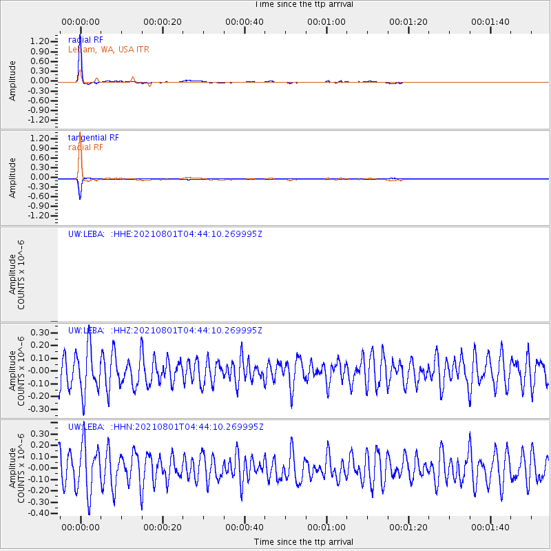
LEBA Lebam, WA, USA - Earthquake Result Viewer

| Earthquake location: |
Dodecanese Islands, Greece |
| Earthquake latitude/longitude: |
36.4/27.0 |
| Earthquake time(UTC): |
2021/08/01 (213) 04:31:27 GMT |
| Earthquake Depth: |
11 km |
| Earthquake Magnitude: |
5.7 mww |
| Earthquake Catalog/Contributor: |
NEIC PDE/us |
|
| Network: |
UW Pacific Northwest Regional Seismic Network |
| Station: |
LEBA Lebam, WA, USA |
| Lat/Lon: |
46.55 N/123.56 W |
| Elevation: |
73 m |
|
| Distance: |
93.3 deg |
| Az: |
340.151 deg |
| Baz: |
23.388 deg |
| Ray Param: |
0.041294284 |
| Estimated Moho Depth: |
61.25 km |
| Estimated Crust Vp/Vs: |
1.91 |
| Assumed Crust Vp: |
6.566 km/s |
| Estimated Crust Vs: |
3.442 km/s |
| Estimated Crust Poisson's Ratio: |
0.31 |
|
| Radial Match: |
98.78784 % |
| Radial Bump: |
166 |
| Transverse Match: |
98.78783 % |
| Transverse Bump: |
166 |
| SOD ConfigId: |
25131211 |
| Insert Time: |
2021-08-15 04:55:04.004 +0000 |
| GWidth: |
2.5 |
| Max Bumps: |
400 |
| Tol: |
0.001 |
|
Signal To Noise
| Channel | StoN | STA | LTA |
| UW:LEBA: :HHZ:20210801T04:44:10.269995Z | 1.8420906 | 1.823038E-7 | 9.89657E-8 |
| UW:LEBA: :HHN:20210801T04:44:10.269995Z | 1.901831 | 2.1944923E-7 | 1.15388396E-7 |
| $trig.getChannelId() | $trig.getValue() | $trig.getSTA() | $trig.getLTA() |
| Arrivals |
| Ps | 8.6 SECOND |
| PpPs | 27 SECOND |
| PsPs/PpSs | 35 SECOND |


