You are here: Home > Network List > UW - Pacific Northwest Regional Seismic Network Stations List
> Station UMAT Pilot Rock, OR, USA > Earthquake Result Viewer
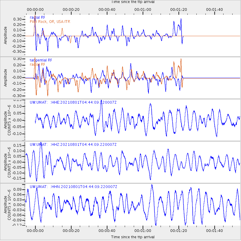
UMAT Pilot Rock, OR, USA - Earthquake Result Viewer
*The percent match for this event was below the threshold and hence no stack was calculated.
| Earthquake location: |
Dodecanese Islands, Greece |
| Earthquake latitude/longitude: |
36.4/27.0 |
| Earthquake time(UTC): |
2021/08/01 (213) 04:31:27 GMT |
| Earthquake Depth: |
11 km |
| Earthquake Magnitude: |
5.7 mww |
| Earthquake Catalog/Contributor: |
NEIC PDE/us |
|
| Network: |
UW Pacific Northwest Regional Seismic Network |
| Station: |
UMAT Pilot Rock, OR, USA |
| Lat/Lon: |
45.29 N/118.96 W |
| Elevation: |
1318 m |
|
| Distance: |
93.1 deg |
| Az: |
336.703 deg |
| Baz: |
26.877 deg |
| Ray Param: |
$rayparam |
*The percent match for this event was below the threshold and hence was not used in the summary stack. |
|
| Radial Match: |
60.859425 % |
| Radial Bump: |
400 |
| Transverse Match: |
53.244957 % |
| Transverse Bump: |
359 |
| SOD ConfigId: |
25131211 |
| Insert Time: |
2021-08-15 04:55:32.154 +0000 |
| GWidth: |
2.5 |
| Max Bumps: |
400 |
| Tol: |
0.001 |
|
Signal To Noise
| Channel | StoN | STA | LTA |
| UW:UMAT: :HHZ:20210801T04:44:09.220007Z | 1.5426288 | 1.0990406E-7 | 7.1244656E-8 |
| UW:UMAT: :HHN:20210801T04:44:09.220007Z | 0.8050288 | 5.6769498E-8 | 7.0518595E-8 |
| UW:UMAT: :HHE:20210801T04:44:09.220007Z | 1.5158468 | 4.847285E-8 | 3.1977404E-8 |
| Arrivals |
| Ps | |
| PpPs | |
| PsPs/PpSs | |


