You are here: Home > Network List > C8 - Canadian Seismic Research Network () Stations List
> Station GRIB Gribbell Island, BC, CA > Earthquake Result Viewer
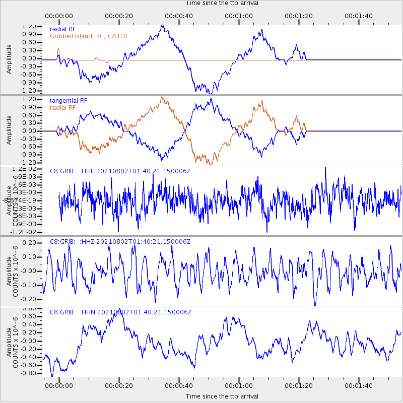
GRIB Gribbell Island, BC, CA - Earthquake Result Viewer
*The percent match for this event was below the threshold and hence no stack was calculated.
| Earthquake location: |
Kermadec Islands, New Zealand |
| Earthquake latitude/longitude: |
-30.4/-177.8 |
| Earthquake time(UTC): |
2021/08/02 (214) 01:27:36 GMT |
| Earthquake Depth: |
10 km |
| Earthquake Magnitude: |
5.6 Mww |
| Earthquake Catalog/Contributor: |
NEIC PDE/us |
|
| Network: |
C8 Canadian Seismic Research Network () |
| Station: |
GRIB Gribbell Island, BC, CA |
| Lat/Lon: |
53.34 N/129.14 W |
| Elevation: |
418 m |
|
| Distance: |
93.5 deg |
| Az: |
26.821 deg |
| Baz: |
220.539 deg |
| Ray Param: |
$rayparam |
*The percent match for this event was below the threshold and hence was not used in the summary stack. |
|
| Radial Match: |
41.993347 % |
| Radial Bump: |
400 |
| Transverse Match: |
42.13335 % |
| Transverse Bump: |
400 |
| SOD ConfigId: |
25131211 |
| Insert Time: |
2021-08-16 01:32:30.677 +0000 |
| GWidth: |
2.5 |
| Max Bumps: |
400 |
| Tol: |
0.001 |
|
Signal To Noise
| Channel | StoN | STA | LTA |
| C8:GRIB: :HHZ:20210802T01:40:21.150006Z | 1.1313119 | 8.131565E-8 | 7.18773E-8 |
| C8:GRIB: :HHN:20210802T01:40:21.150006Z | 1.9415648 | 6.7598245E-7 | 3.4816372E-7 |
| C8:GRIB: :HHE:20210802T01:40:21.150006Z | 1.1291776 | 3.93256E-9 | 3.4826764E-9 |
| Arrivals |
| Ps | |
| PpPs | |
| PsPs/PpSs | |


