You are here: Home > Network List > CC - Cascade Chain Volcano Monitoring Stations List
> Station KAUT Kautz Creek Helibase > Earthquake Result Viewer
KAUT Kautz Creek Helibase - Earthquake Result Viewer
| Earthquake location: |
Kermadec Islands, New Zealand |
| Earthquake latitude/longitude: |
-30.4/-177.8 |
| Earthquake time(UTC): |
2021/08/02 (214) 01:27:36 GMT |
| Earthquake Depth: |
10 km |
| Earthquake Magnitude: |
5.6 Mww |
| Earthquake Catalog/Contributor: |
NEIC PDE/us |
|
| Network: |
CC Cascade Chain Volcano Monitoring |
| Station: |
KAUT Kautz Creek Helibase |
| Lat/Lon: |
46.73 N/121.86 W |
| Elevation: |
689 m |
|
| Distance: |
91.9 deg |
| Az: |
34.772 deg |
| Baz: |
225.742 deg |
| Ray Param: |
0.041545514 |
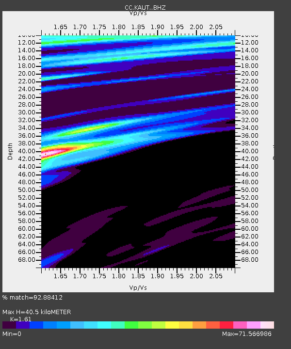
| Estimated Moho Depth: |
40.5 km |
| Estimated Crust Vp/Vs: |
1.61 |
| Assumed Crust Vp: |
6.597 km/s |
| Estimated Crust Vs: |
4.098 km/s |
| Estimated Crust Poisson's Ratio: |
0.19 |
|
| Radial Match: |
92.88412 % |
| Radial Bump: |
400 |
| Transverse Match: |
91.4694 % |
| Transverse Bump: |
400 |
| SOD ConfigId: |
25131211 |
| Insert Time: |
2021-08-16 01:32:43.383 +0000 |
| GWidth: |
2.5 |
| Max Bumps: |
400 |
| Tol: |
0.001 |
|

Signal To Noise
| Channel | StoN | STA | LTA |
| CC:KAUT: :BHZ:20210802T01:40:13.759992Z | 1.6922919 | 3.184854E-7 | 1.8819769E-7 |
| CC:KAUT: :BHN:20210802T01:40:13.759992Z | 3.2597566 | 3.5811325E-5 | 1.0985889E-5 |
| CC:KAUT: :BHE:20210802T01:40:13.759992Z | 2.8275933 | 1.4804226E-5 | 5.2356277E-6 |
| Arrivals |
| Ps | 3.8 SECOND |
| PpPs | 16 SECOND |
| PsPs/PpSs | 19 SECOND |


