You are here: Home > Network List > CI - Caltech Regional Seismic Network Stations List
> Station MPM Manuel Prospect Mine, California, USA > Earthquake Result Viewer
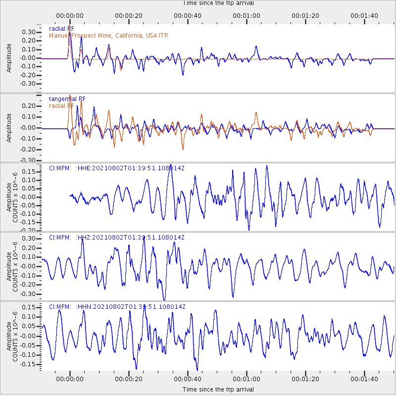
MPM Manuel Prospect Mine, California, USA - Earthquake Result Viewer
*The percent match for this event was below the threshold and hence no stack was calculated.
| Earthquake location: |
Kermadec Islands, New Zealand |
| Earthquake latitude/longitude: |
-30.4/-177.8 |
| Earthquake time(UTC): |
2021/08/02 (214) 01:27:36 GMT |
| Earthquake Depth: |
10 km |
| Earthquake Magnitude: |
5.6 Mww |
| Earthquake Catalog/Contributor: |
NEIC PDE/us |
|
| Network: |
CI Caltech Regional Seismic Network |
| Station: |
MPM Manuel Prospect Mine, California, USA |
| Lat/Lon: |
36.06 N/117.49 W |
| Elevation: |
185 m |
|
| Distance: |
87.1 deg |
| Az: |
44.827 deg |
| Baz: |
228.725 deg |
| Ray Param: |
$rayparam |
*The percent match for this event was below the threshold and hence was not used in the summary stack. |
|
| Radial Match: |
72.9358 % |
| Radial Bump: |
400 |
| Transverse Match: |
69.10751 % |
| Transverse Bump: |
400 |
| SOD ConfigId: |
25131211 |
| Insert Time: |
2021-08-16 01:33:40.072 +0000 |
| GWidth: |
2.5 |
| Max Bumps: |
400 |
| Tol: |
0.001 |
|
Signal To Noise
| Channel | StoN | STA | LTA |
| CI:MPM: :HHZ:20210802T01:39:51.108014Z | 1.903256 | 1.3016526E-7 | 6.8390825E-8 |
| CI:MPM: :HHN:20210802T01:39:51.108014Z | 1.3264922 | 5.8662533E-8 | 4.4223807E-8 |
| CI:MPM: :HHE:20210802T01:39:51.108014Z | 3.0733464 | 1.074536E-7 | 3.4963062E-8 |
| Arrivals |
| Ps | |
| PpPs | |
| PsPs/PpSs | |


