You are here: Home > Network List > AV - Alaska Volcano Observatory Stations List
> Station MAPS Pakushin Southeast, Makushin Volcano, Alaska > Earthquake Result Viewer
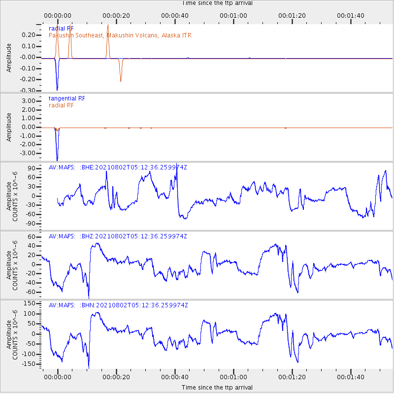
MAPS Pakushin Southeast, Makushin Volcano, Alaska - Earthquake Result Viewer
*The percent match for this event was below the threshold and hence no stack was calculated.
| Earthquake location: |
Irian Jaya Region, Indonesia |
| Earthquake latitude/longitude: |
-4.5/134.0 |
| Earthquake time(UTC): |
2021/08/02 (214) 05:01:20 GMT |
| Earthquake Depth: |
10 km |
| Earthquake Magnitude: |
5.9 mww |
| Earthquake Catalog/Contributor: |
NEIC PDE/us |
|
| Network: |
AV Alaska Volcano Observatory |
| Station: |
MAPS Pakushin Southeast, Makushin Volcano, Alaska |
| Lat/Lon: |
53.81 N/166.94 W |
| Elevation: |
333 m |
|
| Distance: |
76.0 deg |
| Az: |
31.621 deg |
| Baz: |
241.807 deg |
| Ray Param: |
$rayparam |
*The percent match for this event was below the threshold and hence was not used in the summary stack. |
|
| Radial Match: |
99.7981 % |
| Radial Bump: |
26 |
| Transverse Match: |
99.97916 % |
| Transverse Bump: |
7 |
| SOD ConfigId: |
25131211 |
| Insert Time: |
2021-08-16 05:03:53.209 +0000 |
| GWidth: |
2.5 |
| Max Bumps: |
400 |
| Tol: |
0.001 |
|
Signal To Noise
| Channel | StoN | STA | LTA |
| AV:MAPS: :BHZ:20210802T05:12:36.259974Z | 2.2665157 | 3.9076E-5 | 1.724056E-5 |
| AV:MAPS: :BHN:20210802T05:12:36.259974Z | 2.2829924 | 9.1854265E-5 | 4.0234154E-5 |
| AV:MAPS: :BHE:20210802T05:12:36.259974Z | 2.2738461 | 5.8277546E-5 | 2.5629502E-5 |
| Arrivals |
| Ps | |
| PpPs | |
| PsPs/PpSs | |


