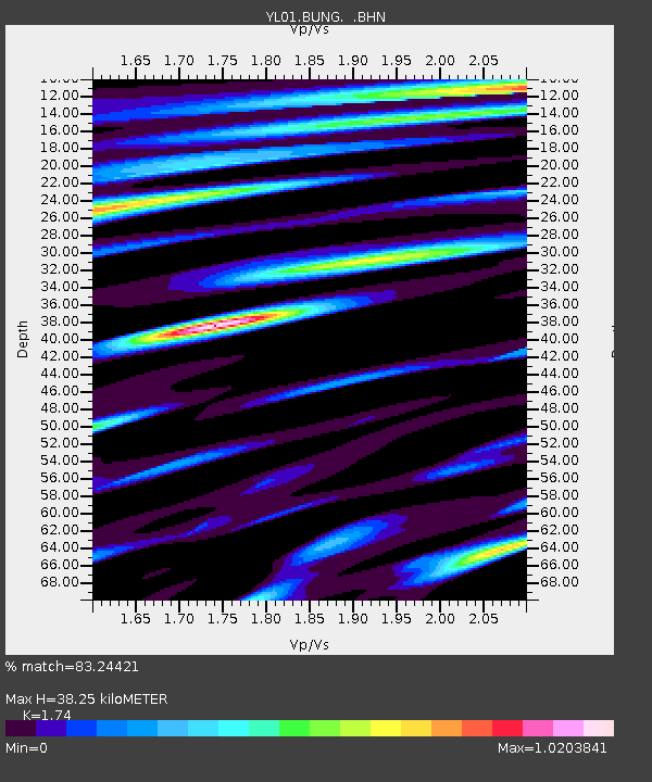
BUNG YL.BUNG - Earthquake Result Viewer
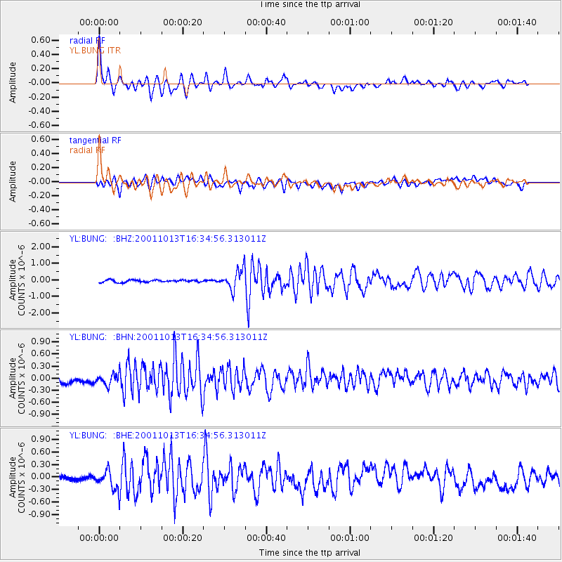
Earthquake location: Northern Molucca Sea
Earthquake latitude/longitude: 0.8/126.0
Earthquake time(UTC): 2001/10/13 (286) 16:27:00 GMT
Earthquake Depth: 33 km
Earthquake Magnitude: 5.6 MB, 5.7 MS, 6.0 MW, 5.8 MW
Earthquake Catalog/Contributor: WHDF/NEIC
Network: YL Himalayan Nepal Tibet Experiment
Station: BUNG YL.BUNG
Lat/Lon: 27.88 N/85.89 E
Elevation: 1191 m
Distance: 46.8 deg
Az: 308.608 deg
Baz: 118.038 deg
Ray Param: 0.070316
Estimated Moho Depth: 38.25 km
Estimated Crust Vp/Vs: 1.74
Assumed Crust Vp: 6.142 km/s
Estimated Crust Vs: 3.53 km/s
Estimated Crust Poisson's Ratio: 0.25
Radial Match: 83.24421 %
Radial Bump: 400
Transverse Match: 66.82267 %
Transverse Bump: 400
SOD ConfigId: 16820
Insert Time: 2010-02-26 15:51:18.661 +0000
GWidth: 2.5
Max Bumps: 400
Tol: 0.001

Signal To Noise

ChannelStoNSTALTA
YL:BUNG: :BHN:20011013T16:34:56.313011Z1.11076861.5166184E-71.3653775E-7
YL:BUNG: :BHE:20011013T16:34:56.313011Z2.6835422.4310324E-79.059043E-8
YL:BUNG: :BHZ:20011013T16:34:56.313011Z9.3327166.239026E-76.685113E-8
Arrivals
Ps4.9 SECOND
PpPs16 SECOND
PsPs/PpSs21 SECOND