You are here: Home > Network List > AV - Alaska Volcano Observatory Stations List
> Station AMKA Regional Station, Amchitka Island, Alaska > Earthquake Result Viewer
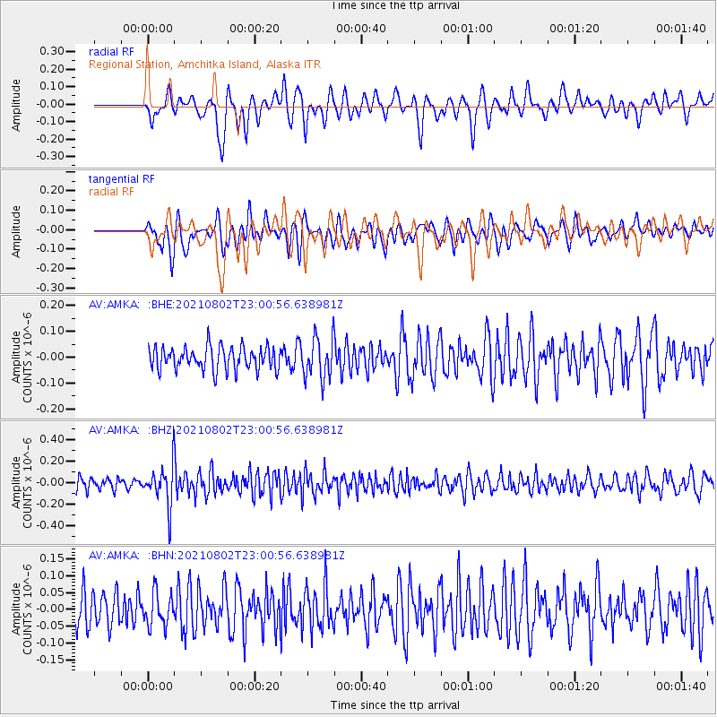
AMKA Regional Station, Amchitka Island, Alaska - Earthquake Result Viewer
*The percent match for this event was below the threshold and hence no stack was calculated.
| Earthquake location: |
Southern Sumatra, Indonesia |
| Earthquake latitude/longitude: |
-3.2/100.2 |
| Earthquake time(UTC): |
2021/08/02 (214) 22:48:49 GMT |
| Earthquake Depth: |
10 km |
| Earthquake Magnitude: |
5.8 mww |
| Earthquake Catalog/Contributor: |
NEIC PDE/us |
|
| Network: |
AV Alaska Volcano Observatory |
| Station: |
AMKA Regional Station, Amchitka Island, Alaska |
| Lat/Lon: |
51.38 N/179.30 E |
| Elevation: |
116 m |
|
| Distance: |
85.7 deg |
| Az: |
38.113 deg |
| Baz: |
259.517 deg |
| Ray Param: |
$rayparam |
*The percent match for this event was below the threshold and hence was not used in the summary stack. |
|
| Radial Match: |
52.306168 % |
| Radial Bump: |
400 |
| Transverse Match: |
50.74195 % |
| Transverse Bump: |
400 |
| SOD ConfigId: |
25131211 |
| Insert Time: |
2021-08-16 22:50:53.879 +0000 |
| GWidth: |
2.5 |
| Max Bumps: |
400 |
| Tol: |
0.001 |
|
Signal To Noise
| Channel | StoN | STA | LTA |
| AV:AMKA: :BHZ:20210802T23:00:56.638981Z | 3.2746272 | 1.9093561E-7 | 5.8307585E-8 |
| AV:AMKA: :BHN:20210802T23:00:56.638981Z | 0.9873964 | 4.8852414E-8 | 4.947599E-8 |
| AV:AMKA: :BHE:20210802T23:00:56.638981Z | 1.8862028 | 8.303384E-8 | 4.402169E-8 |
| Arrivals |
| Ps | |
| PpPs | |
| PsPs/PpSs | |


