You are here: Home > Network List > GO - National Seismic Network of Georgia Stations List
> Station TBLG Delisi, Georgia > Earthquake Result Viewer
TBLG Delisi, Georgia - Earthquake Result Viewer
| Earthquake location: |
Southern Sumatra, Indonesia |
| Earthquake latitude/longitude: |
-3.2/100.2 |
| Earthquake time(UTC): |
2021/08/02 (214) 22:48:49 GMT |
| Earthquake Depth: |
10 km |
| Earthquake Magnitude: |
5.8 mww |
| Earthquake Catalog/Contributor: |
NEIC PDE/us |
|
| Network: |
GO National Seismic Network of Georgia |
| Station: |
TBLG Delisi, Georgia |
| Lat/Lon: |
41.73 N/44.74 E |
| Elevation: |
510 m |
|
| Distance: |
67.2 deg |
| Az: |
318.044 deg |
| Baz: |
116.896 deg |
| Ray Param: |
0.057109598 |
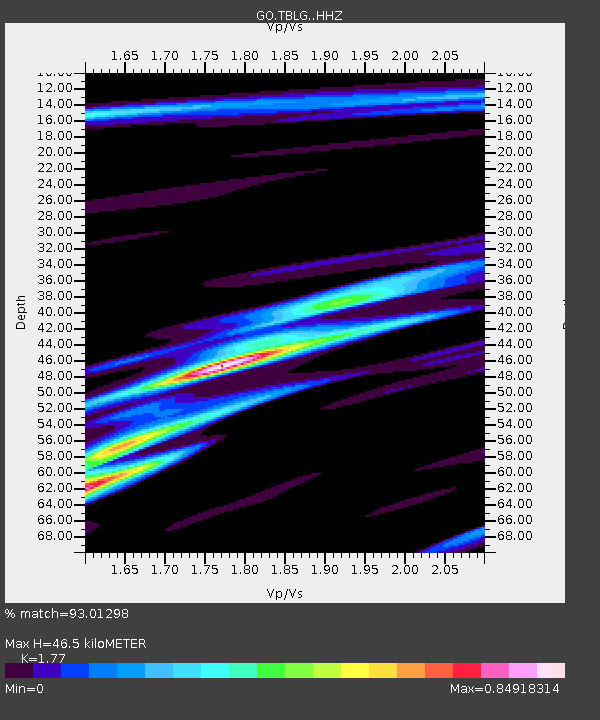
| Estimated Moho Depth: |
46.5 km |
| Estimated Crust Vp/Vs: |
1.77 |
| Assumed Crust Vp: |
6.291 km/s |
| Estimated Crust Vs: |
3.554 km/s |
| Estimated Crust Poisson's Ratio: |
0.27 |
|
| Radial Match: |
93.01298 % |
| Radial Bump: |
347 |
| Transverse Match: |
80.55234 % |
| Transverse Bump: |
400 |
| SOD ConfigId: |
25131211 |
| Insert Time: |
2021-08-16 22:52:39.660 +0000 |
| GWidth: |
2.5 |
| Max Bumps: |
400 |
| Tol: |
0.001 |
|
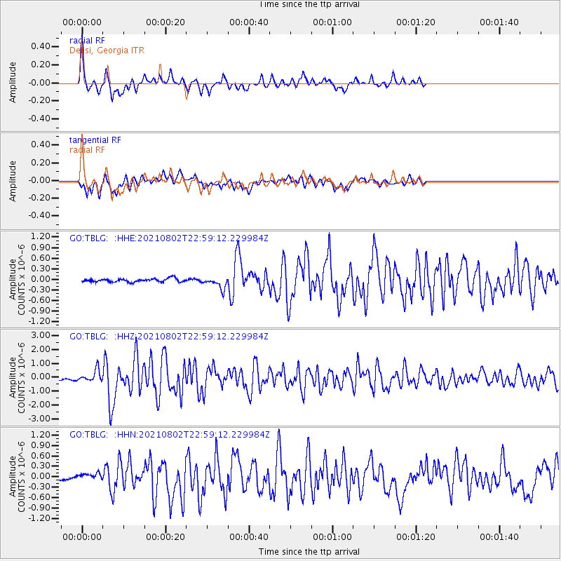
Signal To Noise
| Channel | StoN | STA | LTA |
| GO:TBLG: :HHZ:20210802T22:59:12.229984Z | 4.944582 | 4.388561E-7 | 8.8754945E-8 |
| GO:TBLG: :HHN:20210802T22:59:12.229984Z | 1.7098743 | 1.1134661E-7 | 6.5119764E-8 |
| GO:TBLG: :HHE:20210802T22:59:12.229984Z | 3.610855 | 1.7102305E-7 | 4.7363585E-8 |
| Arrivals |
| Ps | 5.9 SECOND |
| PpPs | 20 SECOND |
| PsPs/PpSs | 26 SECOND |


