You are here: Home > Network List > KR - Kyrgyz Digital Network Stations List
> Station KDJ Kadji-Say, Kyrgyzstan > Earthquake Result Viewer
KDJ Kadji-Say, Kyrgyzstan - Earthquake Result Viewer
| Earthquake location: |
Southern Sumatra, Indonesia |
| Earthquake latitude/longitude: |
-3.2/100.2 |
| Earthquake time(UTC): |
2021/08/02 (214) 22:48:49 GMT |
| Earthquake Depth: |
10 km |
| Earthquake Magnitude: |
5.8 mww |
| Earthquake Catalog/Contributor: |
NEIC PDE/us |
|
| Network: |
KR Kyrgyz Digital Network |
| Station: |
KDJ Kadji-Say, Kyrgyzstan |
| Lat/Lon: |
42.12 N/77.18 E |
| Elevation: |
1830 m |
|
| Distance: |
49.7 deg |
| Az: |
337.6 deg |
| Baz: |
149.241 deg |
| Ray Param: |
0.06855248 |
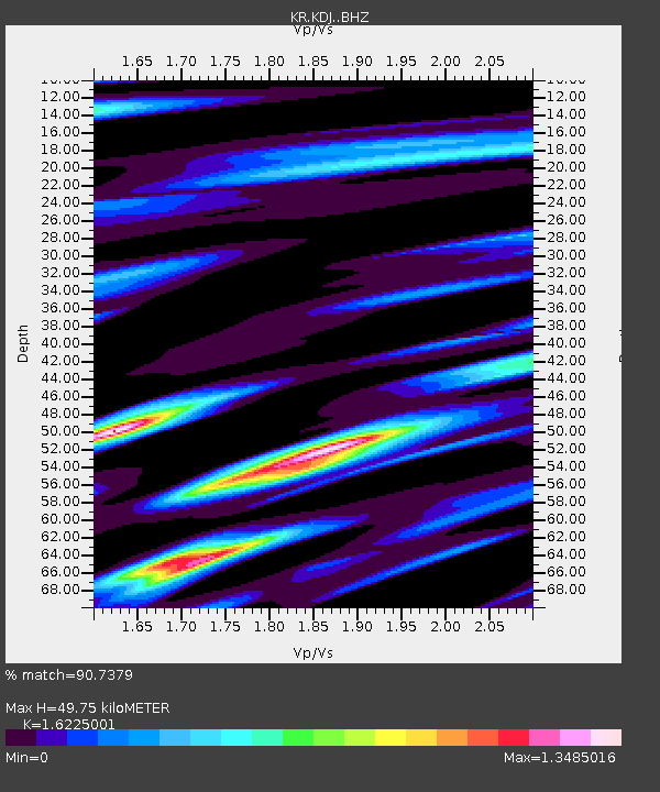
| Estimated Moho Depth: |
49.75 km |
| Estimated Crust Vp/Vs: |
1.62 |
| Assumed Crust Vp: |
6.306 km/s |
| Estimated Crust Vs: |
3.887 km/s |
| Estimated Crust Poisson's Ratio: |
0.19 |
|
| Radial Match: |
90.7379 % |
| Radial Bump: |
400 |
| Transverse Match: |
91.91284 % |
| Transverse Bump: |
400 |
| SOD ConfigId: |
25131211 |
| Insert Time: |
2021-08-16 22:54:19.483 +0000 |
| GWidth: |
2.5 |
| Max Bumps: |
400 |
| Tol: |
0.001 |
|

Signal To Noise
| Channel | StoN | STA | LTA |
| KR:KDJ: :BHZ:20210802T22:57:10.220005Z | 16.161066 | 9.161688E-7 | 5.6689874E-8 |
| KR:KDJ: :BHN:20210802T22:57:10.220005Z | 7.461328 | 2.75423E-7 | 3.69134E-8 |
| KR:KDJ: :BHE:20210802T22:57:10.220005Z | 2.9159033 | 1.2835027E-7 | 4.4017327E-8 |
| Arrivals |
| Ps | 5.2 SECOND |
| PpPs | 19 SECOND |
| PsPs/PpSs | 25 SECOND |


