You are here: Home > Network List > AK - Alaska Regional Network Stations List
> Station E18K Tukpahlearik Creek, AK, USA > Earthquake Result Viewer
E18K Tukpahlearik Creek, AK, USA - Earthquake Result Viewer
| Earthquake location: |
Nicobar Islands, India Region |
| Earthquake latitude/longitude: |
8.9/94.0 |
| Earthquake time(UTC): |
2021/08/03 (215) 03:42:38 GMT |
| Earthquake Depth: |
10 km |
| Earthquake Magnitude: |
6.1 Mww |
| Earthquake Catalog/Contributor: |
NEIC PDE/us |
|
| Network: |
AK Alaska Regional Network |
| Station: |
E18K Tukpahlearik Creek, AK, USA |
| Lat/Lon: |
67.42 N/160.60 W |
| Elevation: |
297 m |
|
| Distance: |
87.7 deg |
| Az: |
21.877 deg |
| Baz: |
287.533 deg |
| Ray Param: |
0.0431305 |
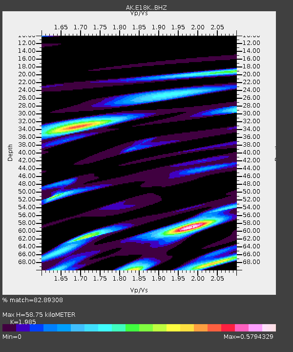
| Estimated Moho Depth: |
58.75 km |
| Estimated Crust Vp/Vs: |
1.99 |
| Assumed Crust Vp: |
6.276 km/s |
| Estimated Crust Vs: |
3.162 km/s |
| Estimated Crust Poisson's Ratio: |
0.33 |
|
| Radial Match: |
82.89308 % |
| Radial Bump: |
400 |
| Transverse Match: |
68.65761 % |
| Transverse Bump: |
400 |
| SOD ConfigId: |
25131211 |
| Insert Time: |
2021-08-17 03:47:02.613 +0000 |
| GWidth: |
2.5 |
| Max Bumps: |
400 |
| Tol: |
0.001 |
|

Signal To Noise
| Channel | StoN | STA | LTA |
| AK:E18K: :BHZ:20210803T03:54:55.499991Z | 3.259496 | 5.372661E-7 | 1.6483104E-7 |
| AK:E18K: :BHN:20210803T03:54:55.499991Z | 1.2965623 | 1.4780245E-7 | 1.1399564E-7 |
| AK:E18K: :BHE:20210803T03:54:55.499991Z | 1.9434816 | 1.9158232E-7 | 9.857686E-8 |
| Arrivals |
| Ps | 9.4 SECOND |
| PpPs | 27 SECOND |
| PsPs/PpSs | 37 SECOND |


