You are here: Home > Network List > US - United States National Seismic Network Stations List
> Station HAWA Hanford, Washington, USA > Earthquake Result Viewer
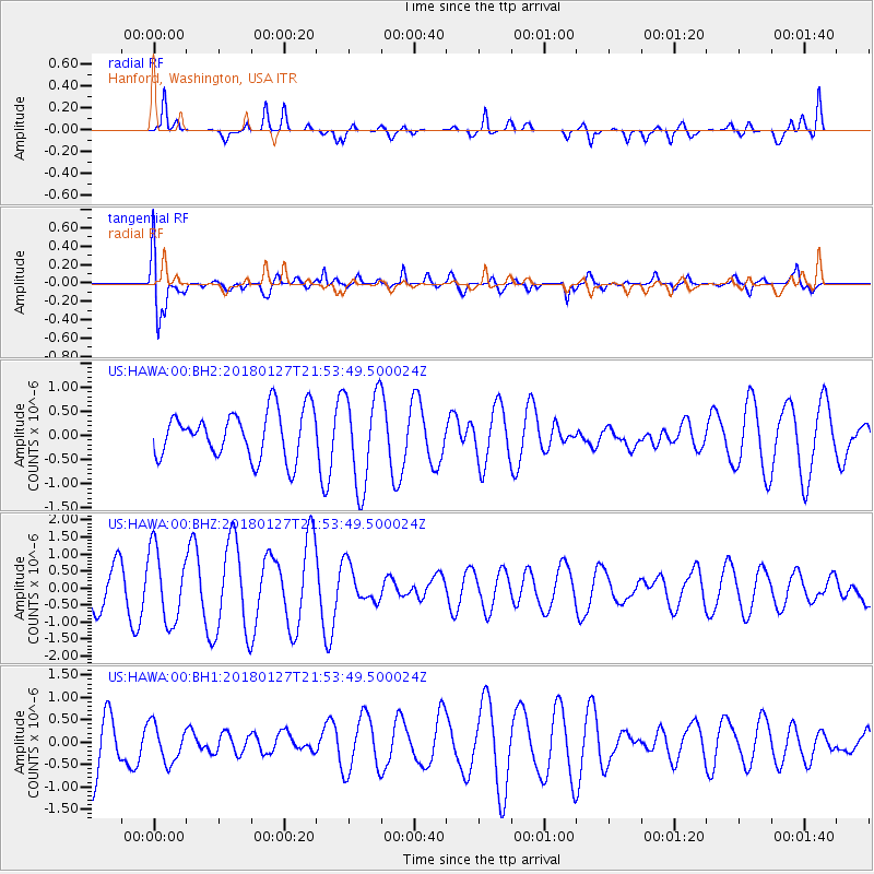
HAWA Hanford, Washington, USA - Earthquake Result Viewer
*The percent match for this event was below the threshold and hence no stack was calculated.
| Earthquake location: |
South Of Panama |
| Earthquake latitude/longitude: |
7.3/-79.7 |
| Earthquake time(UTC): |
2018/01/27 (027) 21:45:12 GMT |
| Earthquake Depth: |
10 km |
| Earthquake Magnitude: |
5.7 Mww |
| Earthquake Catalog/Contributor: |
NEIC PDE/us |
|
| Network: |
US United States National Seismic Network |
| Station: |
HAWA Hanford, Washington, USA |
| Lat/Lon: |
46.39 N/119.53 W |
| Elevation: |
364 m |
|
| Distance: |
51.8 deg |
| Az: |
325.662 deg |
| Baz: |
126.051 deg |
| Ray Param: |
$rayparam |
*The percent match for this event was below the threshold and hence was not used in the summary stack. |
|
| Radial Match: |
69.83948 % |
| Radial Bump: |
400 |
| Transverse Match: |
67.3922 % |
| Transverse Bump: |
400 |
| SOD ConfigId: |
2546091 |
| Insert Time: |
2018-02-10 21:47:32.065 +0000 |
| GWidth: |
2.5 |
| Max Bumps: |
400 |
| Tol: |
0.001 |
|
Signal To Noise
| Channel | StoN | STA | LTA |
| US:HAWA:00:BHZ:20180127T21:53:49.500024Z | 2.4770262 | 1.0624227E-6 | 4.2891054E-7 |
| US:HAWA:00:BH1:20180127T21:53:49.500024Z | 0.76561445 | 4.2299393E-7 | 5.5248944E-7 |
| US:HAWA:00:BH2:20180127T21:53:49.500024Z | 1.9863201 | 9.603026E-7 | 4.834581E-7 |
| Arrivals |
| Ps | |
| PpPs | |
| PsPs/PpSs | |


