BUNG YL.BUNG - Earthquake Result Viewer
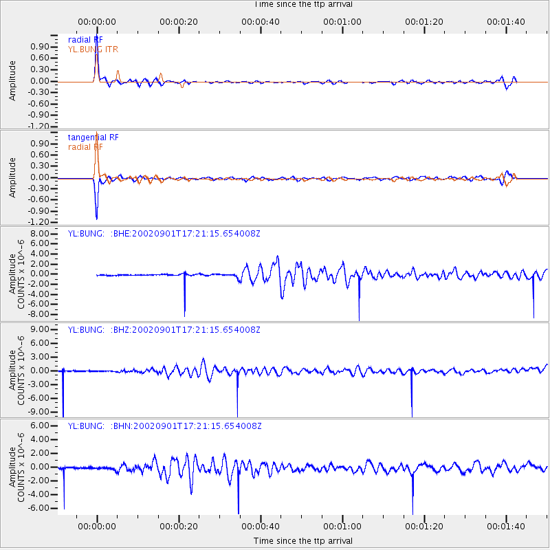
Earthquake location: Eastern Gulf Of Aden
Earthquake latitude/longitude: 14.3/51.9
Earthquake time(UTC): 2002/09/01 (244) 17:14:59 GMT
Earthquake Depth: 10 km
Earthquake Magnitude: 5.8 MS, 5.2 MB, 6.0 MW, 6.0 MW
Earthquake Catalog/Contributor: WHDF/NEIC
Network: YL Himalayan Nepal Tibet Experiment
Station: BUNG YL.BUNG
Lat/Lon: 27.88 N/85.89 E
Elevation: 1191 m
Distance: 34.3 deg
Az: 61.278 deg
Baz: 253.824 deg
Ray Param: 0.07780566
Estimated Moho Depth: 21.25 km
Estimated Crust Vp/Vs: 1.60
Assumed Crust Vp: 6.142 km/s
Estimated Crust Vs: 3.839 km/s
Estimated Crust Poisson's Ratio: 0.18
Radial Match: 84.26498 %
Radial Bump: 246
Transverse Match: 81.83149 %
Transverse Bump: 238
SOD ConfigId: 16820
Insert Time: 2010-02-26 15:51:20.111 +0000
GWidth: 2.5
Max Bumps: 400
Tol: 0.001

Signal To Noise

ChannelStoNSTALTA
YL:BUNG: :BHZ:20020901T17:21:15.654008Z0.192816381.04780476E-75.4342104E-7
YL:BUNG: :BHN:20020901T17:21:15.654008Z0.57370811.877181E-73.2720138E-7
YL:BUNG: :BHE:20020901T17:21:15.654008Z0.883541763.9251026E-74.442464E-7
Arrivals
Ps2.2 SECOND
PpPs8.3 SECOND
PsPs/PpSs11 SECOND