You are here: Home > Network List > G - GEOSCOPE Stations List
> Station FOMA Nahampoana reservation, Fort Dauphin, Madagascar > Earthquake Result Viewer
FOMA Nahampoana reservation, Fort Dauphin, Madagascar - Earthquake Result Viewer
| Earthquake location: |
Southwest Of Africa |
| Earthquake latitude/longitude: |
-53.1/9.7 |
| Earthquake time(UTC): |
2018/01/28 (028) 16:03:03 GMT |
| Earthquake Depth: |
10 km |
| Earthquake Magnitude: |
6.6 Mww |
| Earthquake Catalog/Contributor: |
NEIC PDE/us |
|
| Network: |
G GEOSCOPE |
| Station: |
FOMA Nahampoana reservation, Fort Dauphin, Madagascar |
| Lat/Lon: |
24.98 S/46.98 E |
| Elevation: |
26 m |
|
| Distance: |
39.6 deg |
| Az: |
59.63 deg |
| Baz: |
215.011 deg |
| Ray Param: |
0.07489258 |
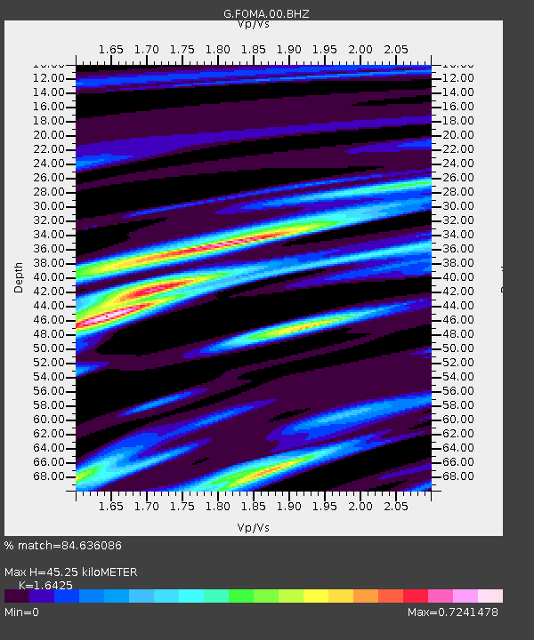
| Estimated Moho Depth: |
45.25 km |
| Estimated Crust Vp/Vs: |
1.64 |
| Assumed Crust Vp: |
6.183 km/s |
| Estimated Crust Vs: |
3.764 km/s |
| Estimated Crust Poisson's Ratio: |
0.21 |
|
| Radial Match: |
84.636086 % |
| Radial Bump: |
342 |
| Transverse Match: |
62.432854 % |
| Transverse Bump: |
400 |
| SOD ConfigId: |
2546091 |
| Insert Time: |
2018-02-11 16:03:38.036 +0000 |
| GWidth: |
2.5 |
| Max Bumps: |
400 |
| Tol: |
0.001 |
|

Signal To Noise
| Channel | StoN | STA | LTA |
| G:FOMA:00:BHZ:20180128T16:10:04.600005Z | 5.252149 | 1.0821493E-6 | 2.0603933E-7 |
| G:FOMA:00:BHN:20180128T16:10:04.600005Z | 2.3675008 | 5.9012064E-7 | 2.492589E-7 |
| G:FOMA:00:BHE:20180128T16:10:04.600005Z | 1.5967443 | 3.7346265E-7 | 2.3389009E-7 |
| Arrivals |
| Ps | 5.0 SECOND |
| PpPs | 18 SECOND |
| PsPs/PpSs | 23 SECOND |


