You are here: Home > Network List > GT - Global Telemetered Seismograph Network (USAF/USGS) Stations List
> Station LBTB Lobatse, Botswana, Africa > Earthquake Result Viewer
LBTB Lobatse, Botswana, Africa - Earthquake Result Viewer
| Earthquake location: |
Southwest Of Africa |
| Earthquake latitude/longitude: |
-53.1/9.7 |
| Earthquake time(UTC): |
2018/01/28 (028) 16:03:03 GMT |
| Earthquake Depth: |
10 km |
| Earthquake Magnitude: |
6.6 Mww |
| Earthquake Catalog/Contributor: |
NEIC PDE/us |
|
| Network: |
GT Global Telemetered Seismograph Network (USAF/USGS) |
| Station: |
LBTB Lobatse, Botswana, Africa |
| Lat/Lon: |
25.02 S/25.60 E |
| Elevation: |
1128 m |
|
| Distance: |
30.5 deg |
| Az: |
29.377 deg |
| Baz: |
199.045 deg |
| Ray Param: |
0.07932348 |
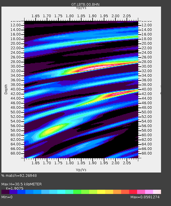
| Estimated Moho Depth: |
30.5 km |
| Estimated Crust Vp/Vs: |
1.91 |
| Assumed Crust Vp: |
6.459 km/s |
| Estimated Crust Vs: |
3.386 km/s |
| Estimated Crust Poisson's Ratio: |
0.31 |
|
| Radial Match: |
92.26948 % |
| Radial Bump: |
364 |
| Transverse Match: |
54.91577 % |
| Transverse Bump: |
400 |
| SOD ConfigId: |
2546091 |
| Insert Time: |
2018-02-11 16:03:56.794 +0000 |
| GWidth: |
2.5 |
| Max Bumps: |
400 |
| Tol: |
0.001 |
|

Signal To Noise
| Channel | StoN | STA | LTA |
| GT:LBTB:00:BHZ:20180128T16:08:46.17401Z | 5.8582945 | 1.2342559E-6 | 2.106852E-7 |
| GT:LBTB:00:BHN:20180128T16:08:46.17401Z | 7.520983 | 9.3050835E-7 | 1.2372163E-7 |
| GT:LBTB:00:BHE:20180128T16:08:46.17401Z | 2.4560378 | 3.8418884E-7 | 1.5642627E-7 |
| Arrivals |
| Ps | 4.6 SECOND |
| PpPs | 13 SECOND |
| PsPs/PpSs | 17 SECOND |


