You are here: Home > Network List > II - Global Seismograph Network (GSN - IRIS/IDA) Stations List
> Station ABPO Ambohimpanompo, Madagascar > Earthquake Result Viewer
ABPO Ambohimpanompo, Madagascar - Earthquake Result Viewer
| Earthquake location: |
Southwest Of Africa |
| Earthquake latitude/longitude: |
-53.1/9.7 |
| Earthquake time(UTC): |
2018/01/28 (028) 16:03:03 GMT |
| Earthquake Depth: |
10 km |
| Earthquake Magnitude: |
6.6 Mww |
| Earthquake Catalog/Contributor: |
NEIC PDE/us |
|
| Network: |
II Global Seismograph Network (GSN - IRIS/IDA) |
| Station: |
ABPO Ambohimpanompo, Madagascar |
| Lat/Lon: |
19.02 S/47.23 E |
| Elevation: |
1528 m |
|
| Distance: |
44.7 deg |
| Az: |
55.072 deg |
| Baz: |
211.534 deg |
| Ray Param: |
0.07176482 |
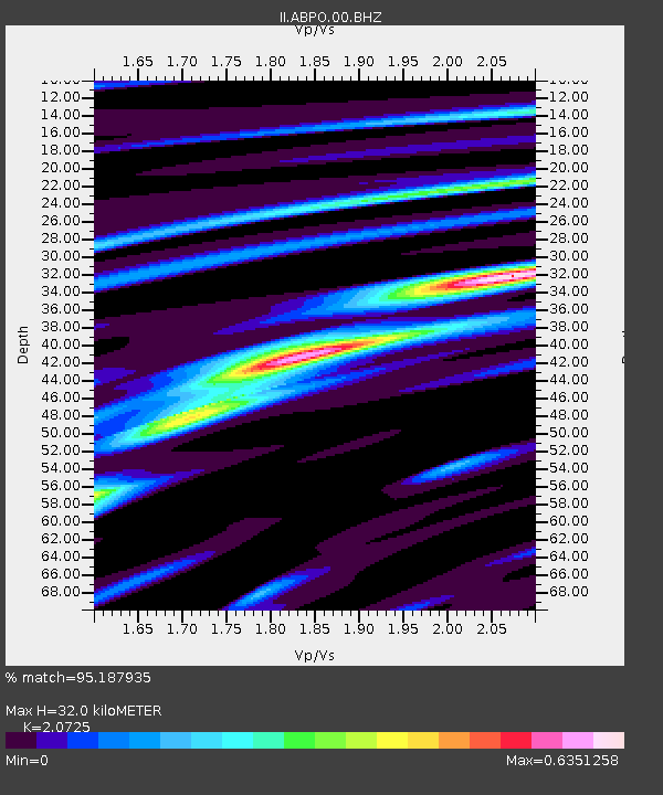
| Estimated Moho Depth: |
32.0 km |
| Estimated Crust Vp/Vs: |
2.07 |
| Assumed Crust Vp: |
6.642 km/s |
| Estimated Crust Vs: |
3.205 km/s |
| Estimated Crust Poisson's Ratio: |
0.35 |
|
| Radial Match: |
95.187935 % |
| Radial Bump: |
237 |
| Transverse Match: |
68.153145 % |
| Transverse Bump: |
400 |
| SOD ConfigId: |
2546091 |
| Insert Time: |
2018-02-11 16:04:02.749 +0000 |
| GWidth: |
2.5 |
| Max Bumps: |
400 |
| Tol: |
0.001 |
|
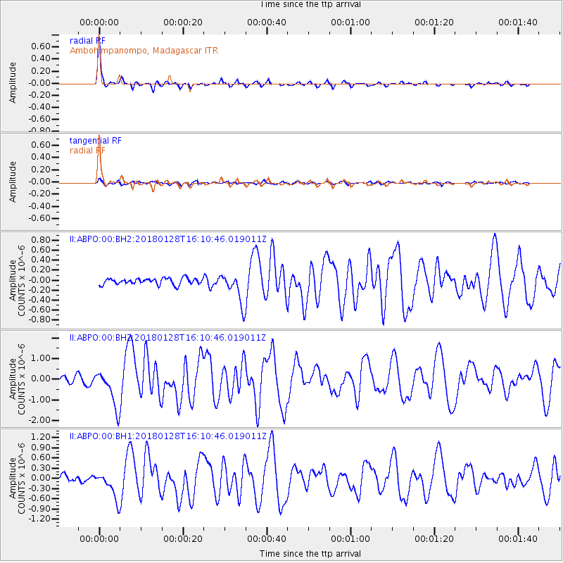
Signal To Noise
| Channel | StoN | STA | LTA |
| II:ABPO:00:BHZ:20180128T16:10:46.019011Z | 4.3008103 | 9.3677465E-7 | 2.1781352E-7 |
| II:ABPO:00:BH1:20180128T16:10:46.019011Z | 3.4797633 | 4.1183583E-7 | 1.18351686E-7 |
| II:ABPO:00:BH2:20180128T16:10:46.019011Z | 5.2817225 | 3.2315586E-7 | 6.11838E-8 |
| Arrivals |
| Ps | 5.5 SECOND |
| PpPs | 14 SECOND |
| PsPs/PpSs | 19 SECOND |


