You are here: Home > Network List > II - Global Seismograph Network (GSN - IRIS/IDA) Stations List
> Station EFI Mount Kent, East Falkland Island > Earthquake Result Viewer
EFI Mount Kent, East Falkland Island - Earthquake Result Viewer
| Earthquake location: |
Southwest Of Africa |
| Earthquake latitude/longitude: |
-53.1/9.7 |
| Earthquake time(UTC): |
2018/01/28 (028) 16:03:03 GMT |
| Earthquake Depth: |
10 km |
| Earthquake Magnitude: |
6.6 Mww |
| Earthquake Catalog/Contributor: |
NEIC PDE/us |
|
| Network: |
II Global Seismograph Network (GSN - IRIS/IDA) |
| Station: |
EFI Mount Kent, East Falkland Island |
| Lat/Lon: |
51.68 S/58.06 W |
| Elevation: |
110 m |
|
| Distance: |
40.0 deg |
| Az: |
243.748 deg |
| Baz: |
119.626 deg |
| Ray Param: |
0.07465981 |
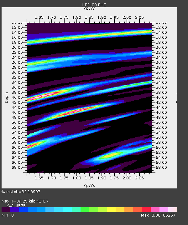
| Estimated Moho Depth: |
39.25 km |
| Estimated Crust Vp/Vs: |
1.66 |
| Assumed Crust Vp: |
6.472 km/s |
| Estimated Crust Vs: |
3.905 km/s |
| Estimated Crust Poisson's Ratio: |
0.21 |
|
| Radial Match: |
82.13997 % |
| Radial Bump: |
371 |
| Transverse Match: |
63.275417 % |
| Transverse Bump: |
400 |
| SOD ConfigId: |
2546091 |
| Insert Time: |
2018-02-11 16:04:05.178 +0000 |
| GWidth: |
2.5 |
| Max Bumps: |
400 |
| Tol: |
0.001 |
|

Signal To Noise
| Channel | StoN | STA | LTA |
| II:EFI:00:BHZ:20180128T16:10:07.818999Z | 3.847749 | 2.6505363E-6 | 6.888538E-7 |
| II:EFI:00:BH1:20180128T16:10:07.818999Z | 1.8238511 | 8.0248856E-7 | 4.3999674E-7 |
| II:EFI:00:BH2:20180128T16:10:07.818999Z | 3.4366448 | 2.13654E-6 | 6.216936E-7 |
| Arrivals |
| Ps | 4.3 SECOND |
| PpPs | 15 SECOND |
| PsPs/PpSs | 19 SECOND |


