You are here: Home > Network List > NM - Cooperative New Madrid Seismic Network Stations List
> Station MPH Memphis, TN > Earthquake Result Viewer
MPH Memphis, TN - Earthquake Result Viewer
| Earthquake location: |
Near Coast Of Peru |
| Earthquake latitude/longitude: |
-17.8/-70.1 |
| Earthquake time(UTC): |
2005/07/13 (194) 12:06:13 GMT |
| Earthquake Depth: |
80 km |
| Earthquake Magnitude: |
5.6 MB, 5.9 MW, 5.8 MW |
| Earthquake Catalog/Contributor: |
WHDF/NEIC |
|
| Network: |
NM Cooperative New Madrid Seismic Network |
| Station: |
MPH Memphis, TN |
| Lat/Lon: |
35.12 N/89.93 W |
| Elevation: |
93 m |
|
| Distance: |
55.9 deg |
| Az: |
340.395 deg |
| Baz: |
157.053 deg |
| Ray Param: |
0.064238876 |
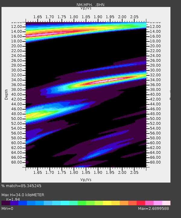
| Estimated Moho Depth: |
34.0 km |
| Estimated Crust Vp/Vs: |
1.94 |
| Assumed Crust Vp: |
6.38 km/s |
| Estimated Crust Vs: |
3.289 km/s |
| Estimated Crust Poisson's Ratio: |
0.32 |
|
| Radial Match: |
85.345245 % |
| Radial Bump: |
400 |
| Transverse Match: |
66.88682 % |
| Transverse Bump: |
400 |
| SOD ConfigId: |
2500 |
| Insert Time: |
2010-03-09 11:16:58.010 +0000 |
| GWidth: |
2.5 |
| Max Bumps: |
400 |
| Tol: |
0.001 |
|

Signal To Noise
| Channel | StoN | STA | LTA |
| NM:MPH: :BHN:20050713T12:15:12.584019Z | 1.4060769 | 1.2019351E-6 | 8.5481463E-7 |
| NM:MPH: :BHE:20050713T12:15:12.584019Z | 1.2615328 | 9.258404E-7 | 7.3390123E-7 |
| NM:MPH: :BHZ:20050713T12:15:12.584019Z | 2.498551 | 1.516042E-6 | 6.0676854E-7 |
| Arrivals |
| Ps | 5.2 SECOND |
| PpPs | 15 SECOND |
| PsPs/PpSs | 20 SECOND |


