You are here: Home > Network List > NM - Cooperative New Madrid Seismic Network Stations List
> Station MPH Memphis, TN > Earthquake Result Viewer
MPH Memphis, TN - Earthquake Result Viewer
| Earthquake location: |
Near Coast Of Peru |
| Earthquake latitude/longitude: |
-13.4/-76.6 |
| Earthquake time(UTC): |
2007/08/15 (227) 23:40:57 GMT |
| Earthquake Depth: |
39 km |
| Earthquake Magnitude: |
6.7 MB, 7.9 MS, 8.0 MW, 7.5 ME |
| Earthquake Catalog/Contributor: |
WHDF/NEIC |
|
| Network: |
NM Cooperative New Madrid Seismic Network |
| Station: |
MPH Memphis, TN |
| Lat/Lon: |
35.12 N/89.93 W |
| Elevation: |
93 m |
|
| Distance: |
49.9 deg |
| Az: |
345.69 deg |
| Baz: |
162.936 deg |
| Ray Param: |
0.06834163 |
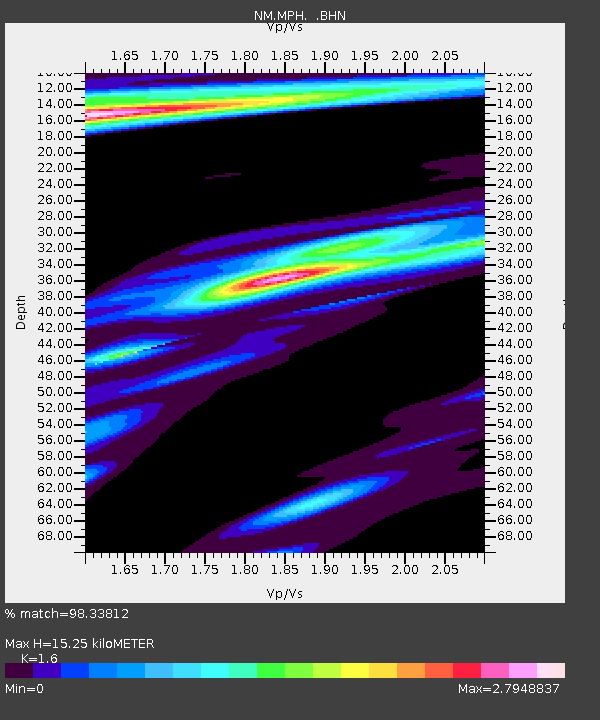
| Estimated Moho Depth: |
15.25 km |
| Estimated Crust Vp/Vs: |
1.60 |
| Assumed Crust Vp: |
6.38 km/s |
| Estimated Crust Vs: |
3.988 km/s |
| Estimated Crust Poisson's Ratio: |
0.18 |
|
| Radial Match: |
98.33812 % |
| Radial Bump: |
334 |
| Transverse Match: |
84.94437 % |
| Transverse Bump: |
400 |
| SOD ConfigId: |
2564 |
| Insert Time: |
2010-03-09 11:17:09.529 +0000 |
| GWidth: |
2.5 |
| Max Bumps: |
400 |
| Tol: |
0.001 |
|

Signal To Noise
| Channel | StoN | STA | LTA |
| NM:MPH: :BHN:20070815T23:49:16.810013Z | 4.9917836 | 4.0992077E-6 | 8.21191E-7 |
| NM:MPH: :BHE:20070815T23:49:16.810013Z | 2.3473167 | 1.5909574E-6 | 6.77777E-7 |
| NM:MPH: :BHZ:20070815T23:49:16.810013Z | 8.904184 | 4.581298E-6 | 5.145107E-7 |
| Arrivals |
| Ps | 1.5 SECOND |
| PpPs | 5.8 SECOND |
| PsPs/PpSs | 7.4 SECOND |


