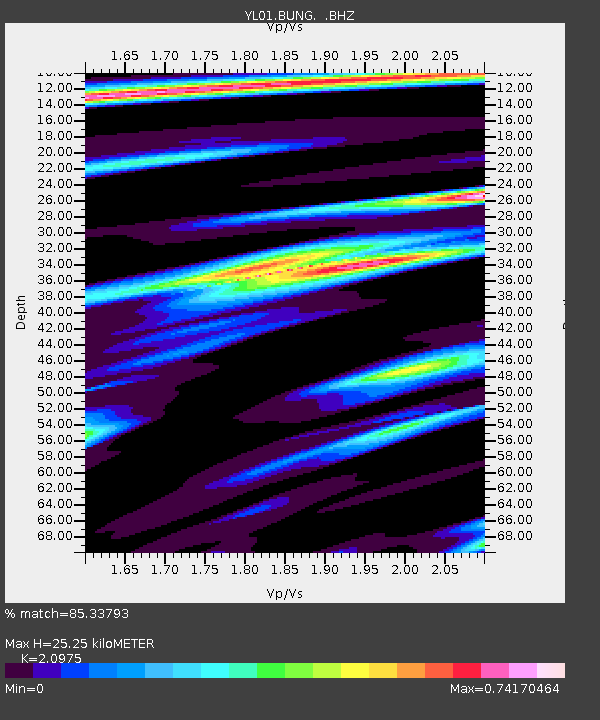
BUNG YL.BUNG - Earthquake Result Viewer

Earthquake location: Vanuatu Islands
Earthquake latitude/longitude: -14.4/167.7
Earthquake time(UTC): 2002/04/11 (101) 21:56:56 GMT
Earthquake Depth: 10 km
Earthquake Magnitude: 5.9 MB, 6.2 MS, 6.2 MW, 6.1 MW
Earthquake Catalog/Contributor: WHDF/NEIC
Network: YL Himalayan Nepal Tibet Experiment
Station: BUNG YL.BUNG
Lat/Lon: 27.88 N/85.89 E
Elevation: 1191 m
Distance: 89.6 deg
Az: 298.811 deg
Baz: 106.438 deg
Ray Param: 0.04175468
Estimated Moho Depth: 25.25 km
Estimated Crust Vp/Vs: 2.10
Assumed Crust Vp: 6.142 km/s
Estimated Crust Vs: 2.928 km/s
Estimated Crust Poisson's Ratio: 0.35
Radial Match: 85.33793 %
Radial Bump: 400
Transverse Match: 73.50325 %
Transverse Bump: 400
SOD ConfigId: 16820
Insert Time: 2010-02-26 15:51:28.834 +0000
GWidth: 2.5
Max Bumps: 400
Tol: 0.001

Signal To Noise

ChannelStoNSTALTA
YL:BUNG: :BHZ:20020411T22:09:22.42302Z1.89674479.07458E-84.7842917E-8
YL:BUNG: :BHN:20020411T22:09:22.42302Z1.7550146.688285E-83.8109583E-8
YL:BUNG: :BHE:20020411T22:09:22.42302Z6.5132132.7188347E-74.174337E-8
Arrivals
Ps4.6 SECOND
PpPs13 SECOND
PsPs/PpSs17 SECOND