You are here: Home > Network List > UU - University of Utah Regional Network Stations List
> Station KNB Kanab, UT, USA > Earthquake Result Viewer
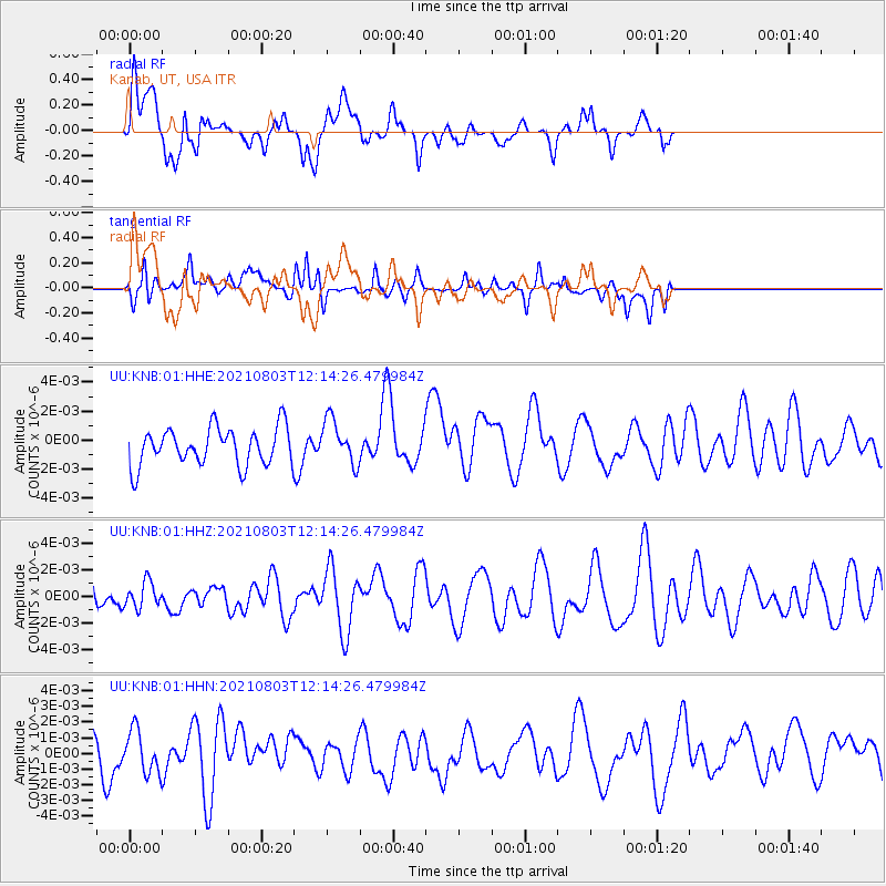
KNB Kanab, UT, USA - Earthquake Result Viewer
*The percent match for this event was below the threshold and hence no stack was calculated.
| Earthquake location: |
Admiralty Islands Region, P.N.G. |
| Earthquake latitude/longitude: |
-1.5/148.1 |
| Earthquake time(UTC): |
2021/08/03 (215) 12:01:21 GMT |
| Earthquake Depth: |
10 km |
| Earthquake Magnitude: |
5.5 Mww |
| Earthquake Catalog/Contributor: |
NEIC PDE/us |
|
| Network: |
UU University of Utah Regional Network |
| Station: |
KNB Kanab, UT, USA |
| Lat/Lon: |
37.02 N/112.82 W |
| Elevation: |
1715 m |
|
| Distance: |
98.1 deg |
| Az: |
52.984 deg |
| Baz: |
274.256 deg |
| Ray Param: |
$rayparam |
*The percent match for this event was below the threshold and hence was not used in the summary stack. |
|
| Radial Match: |
64.60407 % |
| Radial Bump: |
400 |
| Transverse Match: |
63.336388 % |
| Transverse Bump: |
400 |
| SOD ConfigId: |
25131211 |
| Insert Time: |
2021-08-17 12:11:51.569 +0000 |
| GWidth: |
2.5 |
| Max Bumps: |
400 |
| Tol: |
0.001 |
|
Signal To Noise
| Channel | StoN | STA | LTA |
| UU:KNB:01:HHZ:20210803T12:14:26.479984Z | 0.49646324 | 9.656328E-10 | 1.9450237E-9 |
| UU:KNB:01:HHN:20210803T12:14:26.479984Z | 1.052681 | 1.3496576E-9 | 1.2821145E-9 |
| UU:KNB:01:HHE:20210803T12:14:26.479984Z | 1.1860199 | 1.5349321E-9 | 1.2941874E-9 |
| Arrivals |
| Ps | |
| PpPs | |
| PsPs/PpSs | |


